You are here: Home > Network List > GS - US Geological Survey Networks Stations List
> Station OK052 Battle Ridge Rd, NW of Cushing, Oklahoma USA > Earthquake Result Viewer
OK052 Battle Ridge Rd, NW of Cushing, Oklahoma USA - Earthquake Result Viewer
| Earthquake location: |
Near East Coast Of Honshu, Japan |
| Earthquake latitude/longitude: |
35.6/140.7 |
| Earthquake time(UTC): |
2023/05/26 (146) 10:03:24 GMT |
| Earthquake Depth: |
44 km |
| Earthquake Magnitude: |
6.2 mww |
| Earthquake Catalog/Contributor: |
NEIC PDE/us |
|
| Network: |
GS US Geological Survey Networks |
| Station: |
OK052 Battle Ridge Rd, NW of Cushing, Oklahoma USA |
| Lat/Lon: |
36.00 N/96.80 W |
| Elevation: |
261 m |
|
| Distance: |
90.9 deg |
| Az: |
43.147 deg |
| Baz: |
316.598 deg |
| Ray Param: |
0.04165614 |
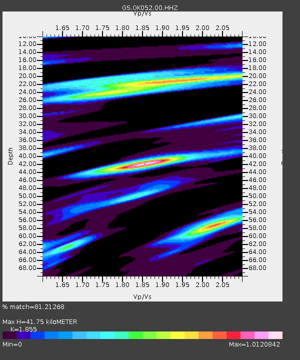
| Estimated Moho Depth: |
41.75 km |
| Estimated Crust Vp/Vs: |
1.86 |
| Assumed Crust Vp: |
6.426 km/s |
| Estimated Crust Vs: |
3.464 km/s |
| Estimated Crust Poisson's Ratio: |
0.30 |
|
| Radial Match: |
81.21268 % |
| Radial Bump: |
400 |
| Transverse Match: |
60.185104 % |
| Transverse Bump: |
400 |
| SOD ConfigId: |
30536071 |
| Insert Time: |
2023-06-09 10:21:08.424 +0000 |
| GWidth: |
2.5 |
| Max Bumps: |
400 |
| Tol: |
0.001 |
|

Signal To Noise
| Channel | StoN | STA | LTA |
| GS:OK052:00:HHZ:20230526T10:15:51.799021Z | 3.923913 | 3.5095226E-7 | 8.943936E-8 |
| GS:OK052:00:HH1:20230526T10:15:51.799021Z | 0.52375025 | 7.699943E-8 | 1.4701554E-7 |
| GS:OK052:00:HH2:20230526T10:15:51.799021Z | 0.95059127 | 1.12500786E-7 | 1.18348225E-7 |
| Arrivals |
| Ps | 5.7 SECOND |
| PpPs | 18 SECOND |
| PsPs/PpSs | 24 SECOND |


