You are here: Home > Network List > MM - Myanmar National Seismic Network Stations List
> Station KTN Keng Tun, Shan, Myanmar > Earthquake Result Viewer
KTN Keng Tun, Shan, Myanmar - Earthquake Result Viewer
| Earthquake location: |
Near East Coast Of Honshu, Japan |
| Earthquake latitude/longitude: |
35.6/140.7 |
| Earthquake time(UTC): |
2023/05/26 (146) 10:03:24 GMT |
| Earthquake Depth: |
44 km |
| Earthquake Magnitude: |
6.2 mww |
| Earthquake Catalog/Contributor: |
NEIC PDE/us |
|
| Network: |
MM Myanmar National Seismic Network |
| Station: |
KTN Keng Tun, Shan, Myanmar |
| Lat/Lon: |
21.29 N/99.59 E |
| Elevation: |
832 m |
|
| Distance: |
38.6 deg |
| Az: |
259.512 deg |
| Baz: |
59.213 deg |
| Ray Param: |
0.07541343 |
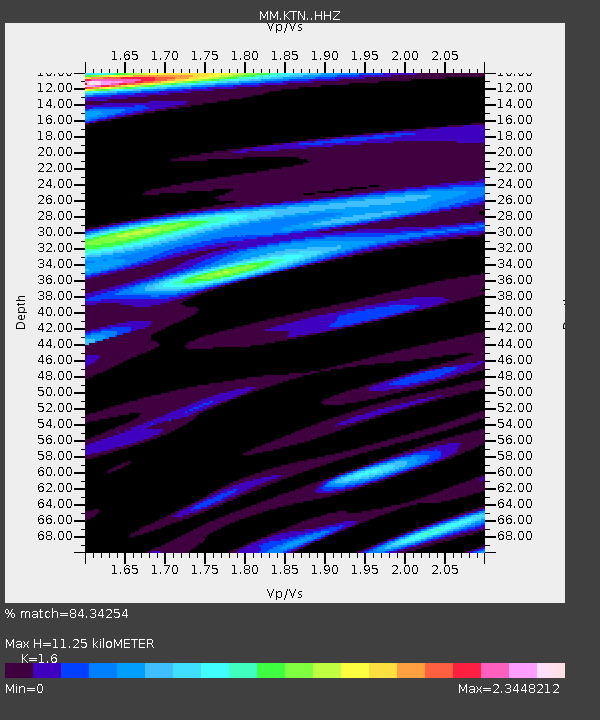
| Estimated Moho Depth: |
11.25 km |
| Estimated Crust Vp/Vs: |
1.60 |
| Assumed Crust Vp: |
6.316 km/s |
| Estimated Crust Vs: |
3.947 km/s |
| Estimated Crust Poisson's Ratio: |
0.18 |
|
| Radial Match: |
84.34254 % |
| Radial Bump: |
400 |
| Transverse Match: |
74.63695 % |
| Transverse Bump: |
400 |
| SOD ConfigId: |
30536071 |
| Insert Time: |
2023-06-09 10:24:41.048 +0000 |
| GWidth: |
2.5 |
| Max Bumps: |
400 |
| Tol: |
0.001 |
|

Signal To Noise
| Channel | StoN | STA | LTA |
| MM:KTN: :HHZ:20230526T10:10:12.068002Z | 6.2341843 | 2.7358035E-6 | 4.3883907E-7 |
| MM:KTN: :HHN:20230526T10:10:12.068002Z | 1.6824561 | 9.991627E-7 | 5.938715E-7 |
| MM:KTN: :HHE:20230526T10:10:12.068002Z | 3.68357 | 2.0569541E-6 | 5.584132E-7 |
| Arrivals |
| Ps | 1.2 SECOND |
| PpPs | 4.3 SECOND |
| PsPs/PpSs | 5.4 SECOND |


