You are here: Home > Network List > IM - International Miscellaneous Stations Stations List
> Station TX31 TXAR Array, Lajitas, TX, USA > Earthquake Result Viewer
TX31 TXAR Array, Lajitas, TX, USA - Earthquake Result Viewer
| Earthquake location: |
Near Coast Of Northern Chile |
| Earthquake latitude/longitude: |
-28.0/-70.8 |
| Earthquake time(UTC): |
2010/03/26 (085) 14:52:07 GMT |
| Earthquake Depth: |
42 km |
| Earthquake Magnitude: |
6.2 MB, 5.9 MS, 6.3 MW, 6.1 MW |
| Earthquake Catalog/Contributor: |
WHDF/NEIC |
|
| Network: |
IM International Miscellaneous Stations |
| Station: |
TX31 TXAR Array, Lajitas, TX, USA |
| Lat/Lon: |
29.33 N/103.67 W |
| Elevation: |
1025 m |
|
| Distance: |
65.1 deg |
| Az: |
328.513 deg |
| Baz: |
148.051 deg |
| Ray Param: |
0.05843976 |
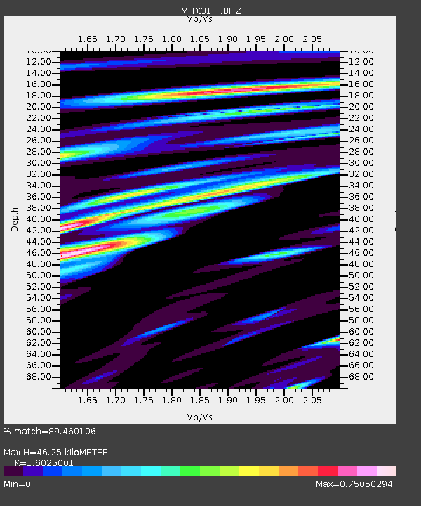
| Estimated Moho Depth: |
46.25 km |
| Estimated Crust Vp/Vs: |
1.60 |
| Assumed Crust Vp: |
6.419 km/s |
| Estimated Crust Vs: |
4.006 km/s |
| Estimated Crust Poisson's Ratio: |
0.18 |
|
| Radial Match: |
89.460106 % |
| Radial Bump: |
400 |
| Transverse Match: |
74.449295 % |
| Transverse Bump: |
400 |
| SOD ConfigId: |
312771 |
| Insert Time: |
2010-06-28 16:17:01.206 +0000 |
| GWidth: |
2.5 |
| Max Bumps: |
400 |
| Tol: |
0.001 |
|

Signal To Noise
| Channel | StoN | STA | LTA |
| IM:TX31: :BHZ:20100326T15:02:12.524983Z | 17.279886 | 8.248687E-8 | 4.773577E-9 |
| IM:TX31: :BHN:20100326T15:02:12.524983Z | 10.437864 | 4.127621E-8 | 3.954469E-9 |
| IM:TX31: :BHE:20100326T15:02:12.524983Z | 5.4732485 | 2.7010794E-8 | 4.935057E-9 |
| Arrivals |
| Ps | 4.5 SECOND |
| PpPs | 18 SECOND |
| PsPs/PpSs | 22 SECOND |


