You are here: Home > Network List > UW - Pacific Northwest Regional Seismic Network Stations List
> Station LMONT Lamont School, Lamont, WA, USA > Earthquake Result Viewer
LMONT Lamont School, Lamont, WA, USA - Earthquake Result Viewer
| Earthquake location: |
Near East Coast Of Honshu, Japan |
| Earthquake latitude/longitude: |
35.6/140.7 |
| Earthquake time(UTC): |
2023/05/26 (146) 10:03:24 GMT |
| Earthquake Depth: |
44 km |
| Earthquake Magnitude: |
6.2 mww |
| Earthquake Catalog/Contributor: |
NEIC PDE/us |
|
| Network: |
UW Pacific Northwest Regional Seismic Network |
| Station: |
LMONT Lamont School, Lamont, WA, USA |
| Lat/Lon: |
47.20 N/117.90 W |
| Elevation: |
598 m |
|
| Distance: |
71.7 deg |
| Az: |
44.746 deg |
| Baz: |
302.732 deg |
| Ray Param: |
0.054086324 |
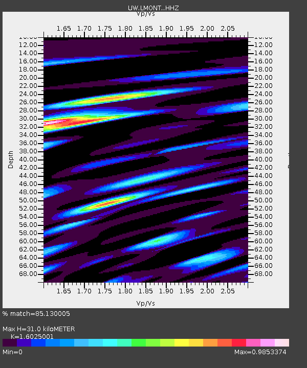
| Estimated Moho Depth: |
31.0 km |
| Estimated Crust Vp/Vs: |
1.60 |
| Assumed Crust Vp: |
6.571 km/s |
| Estimated Crust Vs: |
4.1 km/s |
| Estimated Crust Poisson's Ratio: |
0.18 |
|
| Radial Match: |
85.130005 % |
| Radial Bump: |
400 |
| Transverse Match: |
75.90773 % |
| Transverse Bump: |
400 |
| SOD ConfigId: |
30536071 |
| Insert Time: |
2023-06-09 10:38:36.529 +0000 |
| GWidth: |
2.5 |
| Max Bumps: |
400 |
| Tol: |
0.001 |
|

Signal To Noise
| Channel | StoN | STA | LTA |
| UW:LMONT: :HHZ:20230526T10:14:10.419992Z | 2.1837714 | 1.8177018E-7 | 8.323681E-8 |
| UW:LMONT: :HHN:20230526T10:14:10.419992Z | 1.2690852 | 6.047652E-8 | 4.765364E-8 |
| UW:LMONT: :HHE:20230526T10:14:10.419992Z | 1.8242984 | 1.19170245E-7 | 6.532388E-8 |
| Arrivals |
| Ps | 3.0 SECOND |
| PpPs | 12 SECOND |
| PsPs/PpSs | 15 SECOND |


