You are here: Home > Network List > UW - Pacific Northwest Regional Seismic Network Stations List
> Station PASS Maple Falls, WA, USA > Earthquake Result Viewer
PASS Maple Falls, WA, USA - Earthquake Result Viewer
| Earthquake location: |
Near East Coast Of Honshu, Japan |
| Earthquake latitude/longitude: |
35.6/140.7 |
| Earthquake time(UTC): |
2023/05/26 (146) 10:03:24 GMT |
| Earthquake Depth: |
44 km |
| Earthquake Magnitude: |
6.2 mww |
| Earthquake Catalog/Contributor: |
NEIC PDE/us |
|
| Network: |
UW Pacific Northwest Regional Seismic Network |
| Station: |
PASS Maple Falls, WA, USA |
| Lat/Lon: |
49.00 N/122.09 W |
| Elevation: |
174 m |
|
| Distance: |
68.4 deg |
| Az: |
44.656 deg |
| Baz: |
299.594 deg |
| Ray Param: |
0.056265306 |
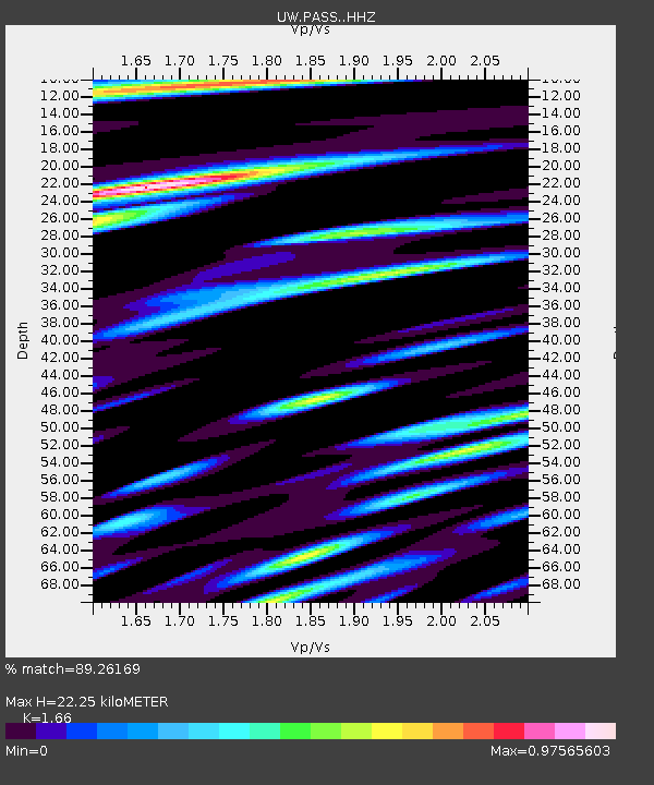
| Estimated Moho Depth: |
22.25 km |
| Estimated Crust Vp/Vs: |
1.66 |
| Assumed Crust Vp: |
6.566 km/s |
| Estimated Crust Vs: |
3.956 km/s |
| Estimated Crust Poisson's Ratio: |
0.22 |
|
| Radial Match: |
89.26169 % |
| Radial Bump: |
400 |
| Transverse Match: |
76.784386 % |
| Transverse Bump: |
400 |
| SOD ConfigId: |
30536071 |
| Insert Time: |
2023-06-09 10:38:58.188 +0000 |
| GWidth: |
2.5 |
| Max Bumps: |
400 |
| Tol: |
0.001 |
|
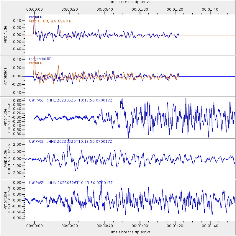
Signal To Noise
| Channel | StoN | STA | LTA |
| UW:PASS: :HHZ:20230526T10:13:50.070017Z | 1.9254961 | 1.362025E-7 | 7.073631E-8 |
| UW:PASS: :HHN:20230526T10:13:50.070017Z | 0.9070034 | 6.216893E-8 | 6.8543216E-8 |
| UW:PASS: :HHE:20230526T10:13:50.070017Z | 1.3582922 | 8.444971E-8 | 6.217345E-8 |
| Arrivals |
| Ps | 2.3 SECOND |
| PpPs | 8.6 SECOND |
| PsPs/PpSs | 11 SECOND |


