You are here: Home > Network List > TA - USArray Transportable Network (new EarthScope stations) Stations List
> Station Z14A Wintersburg, AZ, USA > Earthquake Result Viewer
Z14A Wintersburg, AZ, USA - Earthquake Result Viewer
| Earthquake location: |
Near Coast Of Northern Chile |
| Earthquake latitude/longitude: |
-28.0/-70.8 |
| Earthquake time(UTC): |
2010/03/26 (085) 14:52:07 GMT |
| Earthquake Depth: |
42 km |
| Earthquake Magnitude: |
6.2 MB, 5.9 MS, 6.3 MW, 6.1 MW |
| Earthquake Catalog/Contributor: |
WHDF/NEIC |
|
| Network: |
TA USArray Transportable Network (new EarthScope stations) |
| Station: |
Z14A Wintersburg, AZ, USA |
| Lat/Lon: |
33.36 N/112.95 W |
| Elevation: |
298 m |
|
| Distance: |
72.9 deg |
| Az: |
324.036 deg |
| Baz: |
141.627 deg |
| Ray Param: |
0.053278614 |
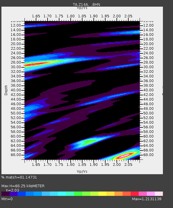
| Estimated Moho Depth: |
68.25 km |
| Estimated Crust Vp/Vs: |
2.03 |
| Assumed Crust Vp: |
6.264 km/s |
| Estimated Crust Vs: |
3.086 km/s |
| Estimated Crust Poisson's Ratio: |
0.34 |
|
| Radial Match: |
81.14731 % |
| Radial Bump: |
400 |
| Transverse Match: |
76.05849 % |
| Transverse Bump: |
392 |
| SOD ConfigId: |
312771 |
| Insert Time: |
2010-06-28 16:21:36.539 +0000 |
| GWidth: |
2.5 |
| Max Bumps: |
400 |
| Tol: |
0.001 |
|

Signal To Noise
| Channel | StoN | STA | LTA |
| TA:Z14A: :BHZ:20100326T15:03:01.12502Z | 12.587136 | 1.7387075E-6 | 1.3813369E-7 |
| TA:Z14A: :BHN:20100326T15:03:01.12502Z | 3.7453506 | 6.118508E-7 | 1.6336274E-7 |
| TA:Z14A: :BHE:20100326T15:03:01.12502Z | 2.107322 | 4.1590607E-7 | 1.9736238E-7 |
| Arrivals |
| Ps | 12 SECOND |
| PpPs | 32 SECOND |
| PsPs/PpSs | 44 SECOND |


