You are here: Home > Network List > TA - USArray Transportable Network (new EarthScope stations) Stations List
> Station W18A Petrified Forest, AZ, USA > Earthquake Result Viewer
W18A Petrified Forest, AZ, USA - Earthquake Result Viewer
| Earthquake location: |
Near Coast Of Northern Chile |
| Earthquake latitude/longitude: |
-28.0/-70.8 |
| Earthquake time(UTC): |
2010/03/26 (085) 14:52:07 GMT |
| Earthquake Depth: |
42 km |
| Earthquake Magnitude: |
6.2 MB, 5.9 MS, 6.3 MW, 6.1 MW |
| Earthquake Catalog/Contributor: |
WHDF/NEIC |
|
| Network: |
TA USArray Transportable Network (new EarthScope stations) |
| Station: |
W18A Petrified Forest, AZ, USA |
| Lat/Lon: |
35.12 N/109.74 W |
| Elevation: |
1750 m |
|
| Distance: |
72.7 deg |
| Az: |
327.362 deg |
| Baz: |
144.409 deg |
| Ray Param: |
0.053410426 |
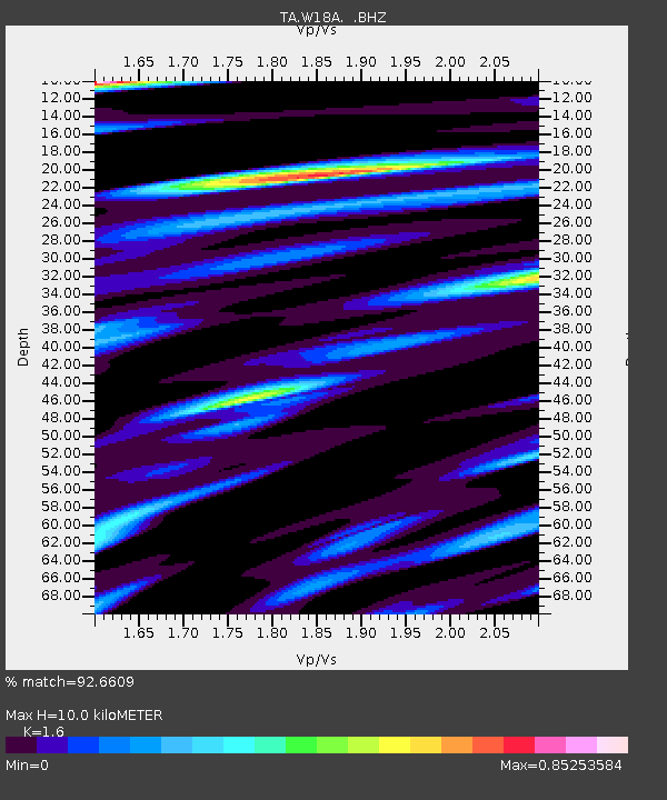
| Estimated Moho Depth: |
10.0 km |
| Estimated Crust Vp/Vs: |
1.60 |
| Assumed Crust Vp: |
6.496 km/s |
| Estimated Crust Vs: |
4.06 km/s |
| Estimated Crust Poisson's Ratio: |
0.18 |
|
| Radial Match: |
92.6609 % |
| Radial Bump: |
366 |
| Transverse Match: |
81.642494 % |
| Transverse Bump: |
400 |
| SOD ConfigId: |
312771 |
| Insert Time: |
2010-06-28 16:22:13.691 +0000 |
| GWidth: |
2.5 |
| Max Bumps: |
400 |
| Tol: |
0.001 |
|

Signal To Noise
| Channel | StoN | STA | LTA |
| TA:W18A: :BHZ:20100326T15:02:59.925007Z | 8.269065 | 2.147933E-6 | 2.5975524E-7 |
| TA:W18A: :BHN:20100326T15:02:59.925007Z | 4.128282 | 9.830089E-7 | 2.3811573E-7 |
| TA:W18A: :BHE:20100326T15:02:59.925007Z | 3.3259568 | 5.6681586E-7 | 1.704219E-7 |
| Arrivals |
| Ps | 1.0 SECOND |
| PpPs | 3.8 SECOND |
| PsPs/PpSs | 4.8 SECOND |


