You are here: Home > Network List > G - GEOSCOPE Stations List
> Station MPG Montagne des Peres, French Guyana > Earthquake Result Viewer
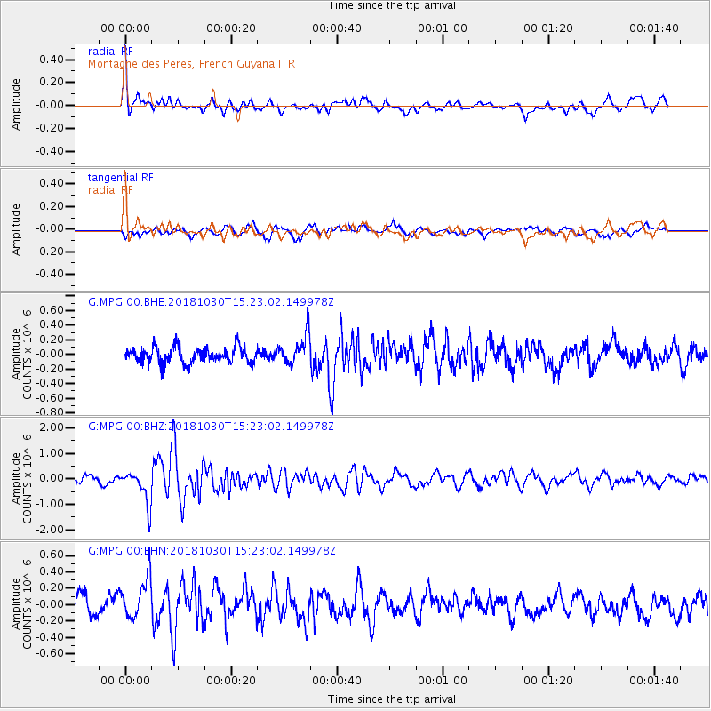
MPG Montagne des Peres, French Guyana - Earthquake Result Viewer
*The percent match for this event was below the threshold and hence no stack was calculated.
| Earthquake location: |
Ionian Sea |
| Earthquake latitude/longitude: |
37.5/20.5 |
| Earthquake time(UTC): |
2018/10/30 (303) 15:12:00 GMT |
| Earthquake Depth: |
11 km |
| Earthquake Magnitude: |
5.7 Mww |
| Earthquake Catalog/Contributor: |
NEIC PDE/us |
|
| Network: |
G GEOSCOPE |
| Station: |
MPG Montagne des Peres, French Guyana |
| Lat/Lon: |
5.11 N/52.64 W |
| Elevation: |
147 m |
|
| Distance: |
73.5 deg |
| Az: |
263.732 deg |
| Baz: |
52.519 deg |
| Ray Param: |
$rayparam |
*The percent match for this event was below the threshold and hence was not used in the summary stack. |
|
| Radial Match: |
72.1988 % |
| Radial Bump: |
400 |
| Transverse Match: |
58.06536 % |
| Transverse Bump: |
400 |
| SOD ConfigId: |
3103472 |
| Insert Time: |
2018-11-13 15:26:26.795 +0000 |
| GWidth: |
2.5 |
| Max Bumps: |
400 |
| Tol: |
0.001 |
|
Signal To Noise
| Channel | StoN | STA | LTA |
| G:MPG:00:BHZ:20181030T15:23:02.149978Z | 4.7376637 | 6.574109E-7 | 1.3876267E-7 |
| G:MPG:00:BHN:20181030T15:23:02.149978Z | 2.040308 | 2.7932043E-7 | 1.3690112E-7 |
| G:MPG:00:BHE:20181030T15:23:02.149978Z | 1.9076446 | 2.0907223E-7 | 1.09597046E-7 |
| Arrivals |
| Ps | |
| PpPs | |
| PsPs/PpSs | |


