You are here: Home > Network List > AK - Alaska Regional Network Stations List
> Station L16K Owhat River, AK, USA > Earthquake Result Viewer
L16K Owhat River, AK, USA - Earthquake Result Viewer
| Earthquake location: |
Tonga Islands |
| Earthquake latitude/longitude: |
-18.5/-175.2 |
| Earthquake time(UTC): |
2023/05/27 (147) 00:11:00 GMT |
| Earthquake Depth: |
215 km |
| Earthquake Magnitude: |
6.0 mww |
| Earthquake Catalog/Contributor: |
NEIC PDE/us |
|
| Network: |
AK Alaska Regional Network |
| Station: |
L16K Owhat River, AK, USA |
| Lat/Lon: |
61.71 N/159.47 W |
| Elevation: |
227 m |
|
| Distance: |
80.9 deg |
| Az: |
7.514 deg |
| Baz: |
195.102 deg |
| Ray Param: |
0.047443032 |
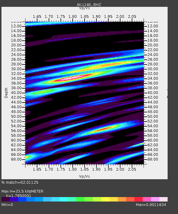
| Estimated Moho Depth: |
33.5 km |
| Estimated Crust Vp/Vs: |
1.80 |
| Assumed Crust Vp: |
6.276 km/s |
| Estimated Crust Vs: |
3.496 km/s |
| Estimated Crust Poisson's Ratio: |
0.27 |
|
| Radial Match: |
82.01125 % |
| Radial Bump: |
400 |
| Transverse Match: |
70.24155 % |
| Transverse Bump: |
400 |
| SOD ConfigId: |
30536071 |
| Insert Time: |
2023-06-10 00:15:18.767 +0000 |
| GWidth: |
2.5 |
| Max Bumps: |
400 |
| Tol: |
0.001 |
|

Signal To Noise
| Channel | StoN | STA | LTA |
| AK:L16K: :BHZ:20230527T00:22:19.239972Z | 11.079471 | 1.0793367E-6 | 9.741772E-8 |
| AK:L16K: :BHN:20230527T00:22:19.239972Z | 5.8675394 | 3.4426125E-7 | 5.8672168E-8 |
| AK:L16K: :BHE:20230527T00:22:19.239972Z | 2.4631226 | 2.7752387E-7 | 1.12671565E-7 |
| Arrivals |
| Ps | 4.4 SECOND |
| PpPs | 15 SECOND |
| PsPs/PpSs | 19 SECOND |


