You are here: Home > Network List > GS - US Geological Survey Networks Stations List
> Station KAN13 Rinehart Farm > Earthquake Result Viewer
KAN13 Rinehart Farm - Earthquake Result Viewer
*The percent match for this event was below the threshold and hence no stack was calculated.
| Earthquake location: |
Ionian Sea |
| Earthquake latitude/longitude: |
37.5/20.5 |
| Earthquake time(UTC): |
2018/10/30 (303) 15:12:00 GMT |
| Earthquake Depth: |
11 km |
| Earthquake Magnitude: |
5.7 Mww |
| Earthquake Catalog/Contributor: |
NEIC PDE/us |
|
| Network: |
GS US Geological Survey Networks |
| Station: |
KAN13 Rinehart Farm |
| Lat/Lon: |
37.01 N/97.48 W |
| Elevation: |
340 m |
|
| Distance: |
86.3 deg |
| Az: |
314.901 deg |
| Baz: |
44.723 deg |
| Ray Param: |
$rayparam |
*The percent match for this event was below the threshold and hence was not used in the summary stack. |
|
| Radial Match: |
30.570946 % |
| Radial Bump: |
400 |
| Transverse Match: |
20.120937 % |
| Transverse Bump: |
400 |
| SOD ConfigId: |
3103472 |
| Insert Time: |
2018-11-13 15:26:55.608 +0000 |
| GWidth: |
2.5 |
| Max Bumps: |
400 |
| Tol: |
0.001 |
|
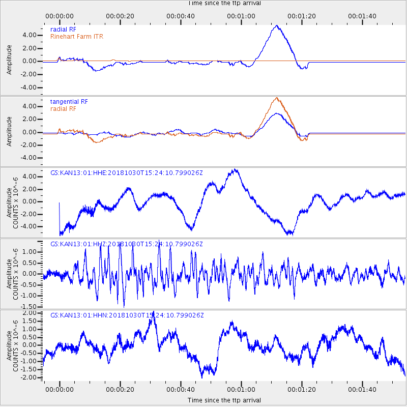
Signal To Noise
| Channel | StoN | STA | LTA |
| GS:KAN13:01:HHZ:20181030T15:24:10.799026Z | 0.7968477 | 1.6794085E-7 | 2.1075654E-7 |
| GS:KAN13:01:HHN:20181030T15:24:10.799026Z | 0.56737417 | 4.058237E-7 | 7.152664E-7 |
| GS:KAN13:01:HHE:20181030T15:24:10.799026Z | 1.1566597 | 2.2907136E-6 | 1.9804559E-6 |
| Arrivals |
| Ps | |
| PpPs | |
| PsPs/PpSs | |


