You are here: Home > Network List > TA - USArray Transportable Network (new EarthScope stations) Stations List
> Station U25A Circle Dot Ranch, Maxwell, NM, USA > Earthquake Result Viewer
U25A Circle Dot Ranch, Maxwell, NM, USA - Earthquake Result Viewer
| Earthquake location: |
Near Coast Of Northern Chile |
| Earthquake latitude/longitude: |
-28.0/-70.8 |
| Earthquake time(UTC): |
2010/03/26 (085) 14:52:07 GMT |
| Earthquake Depth: |
42 km |
| Earthquake Magnitude: |
6.2 MB, 5.9 MS, 6.3 MW, 6.1 MW |
| Earthquake Catalog/Contributor: |
WHDF/NEIC |
|
| Network: |
TA USArray Transportable Network (new EarthScope stations) |
| Station: |
U25A Circle Dot Ranch, Maxwell, NM, USA |
| Lat/Lon: |
36.40 N/104.41 W |
| Elevation: |
1845 m |
|
| Distance: |
71.4 deg |
| Az: |
331.905 deg |
| Baz: |
148.911 deg |
| Ray Param: |
0.05428252 |
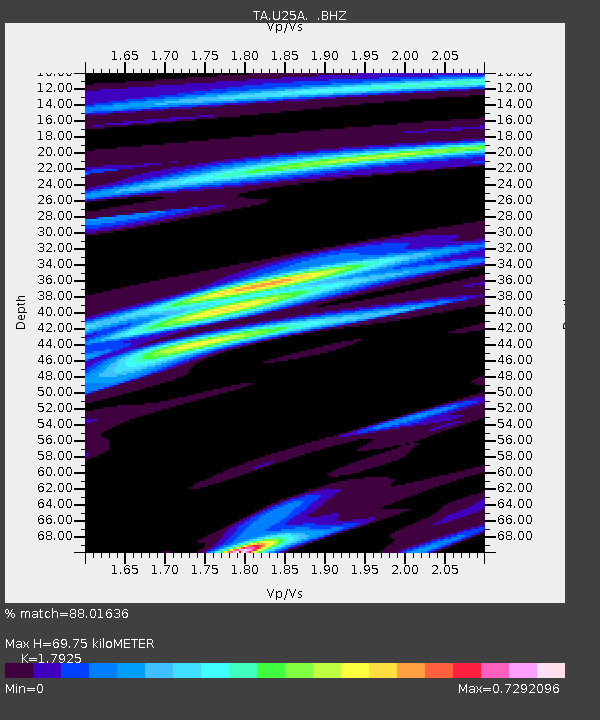
| Estimated Moho Depth: |
69.75 km |
| Estimated Crust Vp/Vs: |
1.79 |
| Assumed Crust Vp: |
6.316 km/s |
| Estimated Crust Vs: |
3.523 km/s |
| Estimated Crust Poisson's Ratio: |
0.27 |
|
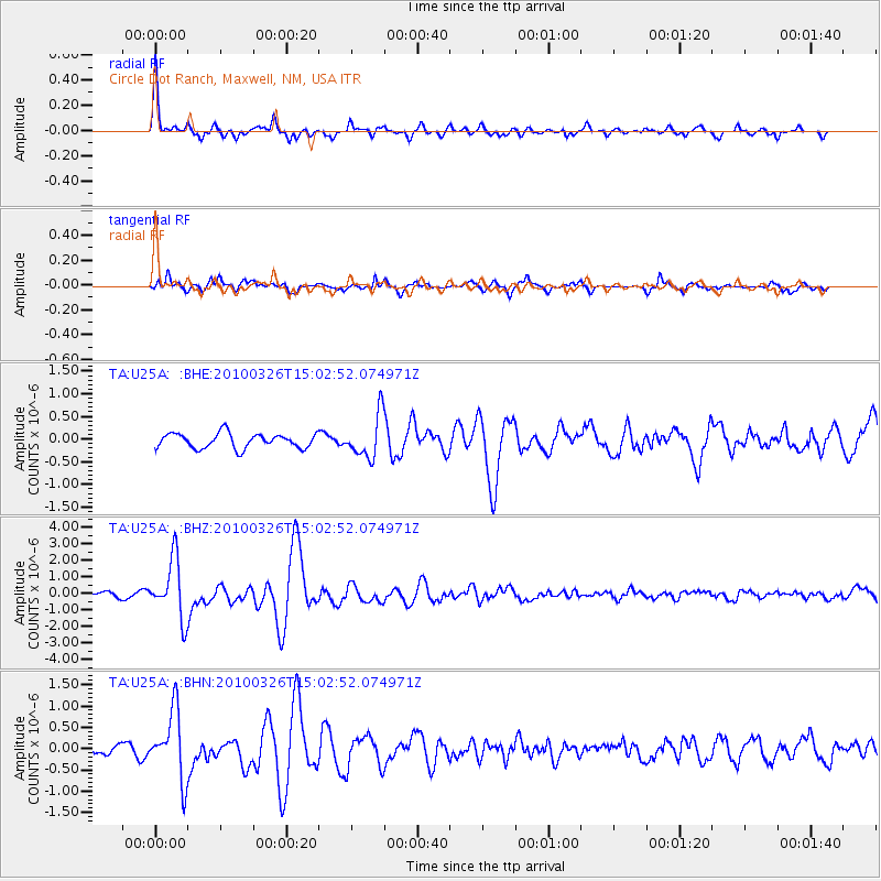
| Radial Match: |
88.01636 % |
| Radial Bump: |
342 |
| Transverse Match: |
73.10373 % |
| Transverse Bump: |
395 |
| SOD ConfigId: |
312771 |
| Insert Time: |
2010-06-28 16:24:14.980 +0000 |
| GWidth: |
2.5 |
| Max Bumps: |
400 |
| Tol: |
0.001 |
|
Signal To Noise
| Channel | StoN | STA | LTA |
| TA:U25A: :BHZ:20100326T15:02:52.074971Z | 6.8837886 | 1.7777157E-6 | 2.582467E-7 |
| TA:U25A: :BHN:20100326T15:02:52.074971Z | 6.5955973 | 7.973142E-7 | 1.2088582E-7 |
| TA:U25A: :BHE:20100326T15:02:52.074971Z | 2.9210298 | 4.705924E-7 | 1.6110496E-7 |
| Arrivals |
| Ps | 9.1 SECOND |
| PpPs | 30 SECOND |
| PsPs/PpSs | 39 SECOND |


