You are here: Home > Network List > AV - Alaska Volcano Observatory Stations List
> Station MAPS Pakushin Southeast, Makushin Volcano, Alaska > Earthquake Result Viewer
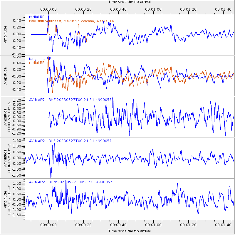
MAPS Pakushin Southeast, Makushin Volcano, Alaska - Earthquake Result Viewer
*The percent match for this event was below the threshold and hence no stack was calculated.
| Earthquake location: |
Tonga Islands |
| Earthquake latitude/longitude: |
-18.5/-175.2 |
| Earthquake time(UTC): |
2023/05/27 (147) 00:11:00 GMT |
| Earthquake Depth: |
215 km |
| Earthquake Magnitude: |
6.0 mww |
| Earthquake Catalog/Contributor: |
NEIC PDE/us |
|
| Network: |
AV Alaska Volcano Observatory |
| Station: |
MAPS Pakushin Southeast, Makushin Volcano, Alaska |
| Lat/Lon: |
53.81 N/166.94 W |
| Elevation: |
333 m |
|
| Distance: |
72.3 deg |
| Az: |
5.13 deg |
| Baz: |
188.227 deg |
| Ray Param: |
$rayparam |
*The percent match for this event was below the threshold and hence was not used in the summary stack. |
|
| Radial Match: |
48.270912 % |
| Radial Bump: |
400 |
| Transverse Match: |
52.028206 % |
| Transverse Bump: |
400 |
| SOD ConfigId: |
30536071 |
| Insert Time: |
2023-06-10 00:20:16.285 +0000 |
| GWidth: |
2.5 |
| Max Bumps: |
400 |
| Tol: |
0.001 |
|
Signal To Noise
| Channel | StoN | STA | LTA |
| AV:MAPS: :BHZ:20230527T00:21:31.499005Z | 2.876536 | 7.1443503E-7 | 2.4836646E-7 |
| AV:MAPS: :BHN:20230527T00:21:31.499005Z | 2.0544055 | 7.9334666E-7 | 3.861685E-7 |
| AV:MAPS: :BHE:20230527T00:21:31.499005Z | 1.5364324 | 5.349955E-7 | 3.4820633E-7 |
| Arrivals |
| Ps | |
| PpPs | |
| PsPs/PpSs | |


