You are here: Home > Network List > TA - USArray Transportable Network (new EarthScope stations) Stations List
> Station L23A Garrett, WY, USA > Earthquake Result Viewer
L23A Garrett, WY, USA - Earthquake Result Viewer
| Earthquake location: |
Near Coast Of Northern Chile |
| Earthquake latitude/longitude: |
-28.0/-70.8 |
| Earthquake time(UTC): |
2010/03/26 (085) 14:52:07 GMT |
| Earthquake Depth: |
42 km |
| Earthquake Magnitude: |
6.2 MB, 5.9 MS, 6.3 MW, 6.1 MW |
| Earthquake Catalog/Contributor: |
WHDF/NEIC |
|
| Network: |
TA USArray Transportable Network (new EarthScope stations) |
| Station: |
L23A Garrett, WY, USA |
| Lat/Lon: |
42.11 N/105.70 W |
| Elevation: |
2153 m |
|
| Distance: |
76.8 deg |
| Az: |
334.085 deg |
| Baz: |
148.693 deg |
| Ray Param: |
0.05068382 |
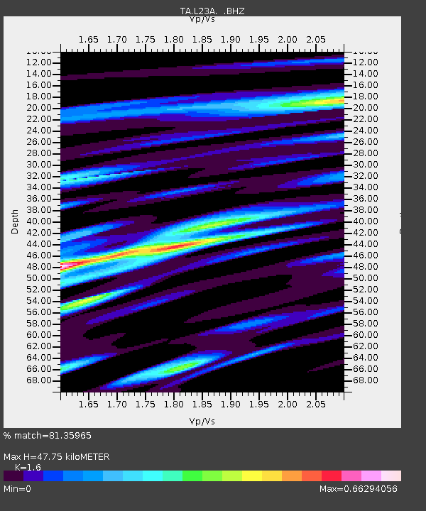
| Estimated Moho Depth: |
47.75 km |
| Estimated Crust Vp/Vs: |
1.60 |
| Assumed Crust Vp: |
6.159 km/s |
| Estimated Crust Vs: |
3.849 km/s |
| Estimated Crust Poisson's Ratio: |
0.18 |
|
| Radial Match: |
81.35965 % |
| Radial Bump: |
400 |
| Transverse Match: |
51.420956 % |
| Transverse Bump: |
394 |
| SOD ConfigId: |
312771 |
| Insert Time: |
2010-06-28 16:26:57.321 +0000 |
| GWidth: |
2.5 |
| Max Bumps: |
400 |
| Tol: |
0.001 |
|
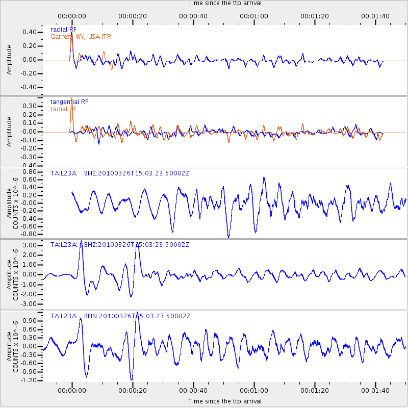
Signal To Noise
| Channel | StoN | STA | LTA |
| TA:L23A: :BHZ:20100326T15:03:23.50002Z | 6.029566 | 1.5076918E-6 | 2.500498E-7 |
| TA:L23A: :BHN:20100326T15:03:23.50002Z | 3.0795882 | 5.5990245E-7 | 1.8181082E-7 |
| TA:L23A: :BHE:20100326T15:03:23.50002Z | 1.8061731 | 3.316704E-7 | 1.8363157E-7 |
| Arrivals |
| Ps | 4.8 SECOND |
| PpPs | 20 SECOND |
| PsPs/PpSs | 24 SECOND |


