You are here: Home > Network List > TA - USArray Transportable Network (new EarthScope stations) Stations List
> Station I21A Big Trails, Ten Sleep, WY, USA > Earthquake Result Viewer
I21A Big Trails, Ten Sleep, WY, USA - Earthquake Result Viewer

| Earthquake location: |
Near Coast Of Northern Chile |
| Earthquake latitude/longitude: |
-28.0/-70.8 |
| Earthquake time(UTC): |
2010/03/26 (085) 14:52:07 GMT |
| Earthquake Depth: |
42 km |
| Earthquake Magnitude: |
6.2 MB, 5.9 MS, 6.3 MW, 6.1 MW |
| Earthquake Catalog/Contributor: |
WHDF/NEIC |
|
| Network: |
TA USArray Transportable Network (new EarthScope stations) |
| Station: |
I21A Big Trails, Ten Sleep, WY, USA |
| Lat/Lon: |
43.81 N/107.29 W |
| Elevation: |
1639 m |
|
| Distance: |
78.9 deg |
| Az: |
333.986 deg |
| Baz: |
147.592 deg |
| Ray Param: |
0.049291514 |
| Estimated Moho Depth: |
12.5 km |
| Estimated Crust Vp/Vs: |
1.99 |
| Assumed Crust Vp: |
6.178 km/s |
| Estimated Crust Vs: |
3.105 km/s |
| Estimated Crust Poisson's Ratio: |
0.33 |
|
| Radial Match: |
82.74322 % |
| Radial Bump: |
400 |
| Transverse Match: |
75.12015 % |
| Transverse Bump: |
400 |
| SOD ConfigId: |
312771 |
| Insert Time: |
2010-06-28 16:27:35.642 +0000 |
| GWidth: |
2.5 |
| Max Bumps: |
400 |
| Tol: |
0.001 |
|
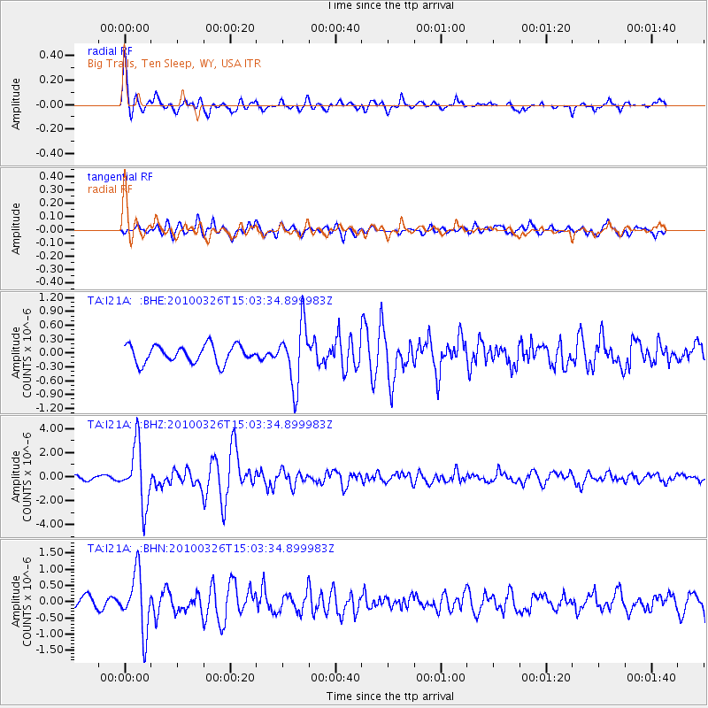
Signal To Noise
| Channel | StoN | STA | LTA |
| TA:I21A: :BHZ:20100326T15:03:34.899983Z | 15.516594 | 2.4864842E-6 | 1.6024677E-7 |
| TA:I21A: :BHN:20100326T15:03:34.899983Z | 5.679494 | 9.014874E-7 | 1.587267E-7 |
| TA:I21A: :BHE:20100326T15:03:34.899983Z | 3.4673235 | 6.559676E-7 | 1.8918558E-7 |
| Arrivals |
| Ps | 2.1 SECOND |
| PpPs | 5.9 SECOND |
| PsPs/PpSs | 8.0 SECOND |


