You are here: Home > Network List > TA - USArray Transportable Network (new EarthScope stations) Stations List
> Station A21A Bergtoll Ranch, Theony, MT, USA > Earthquake Result Viewer
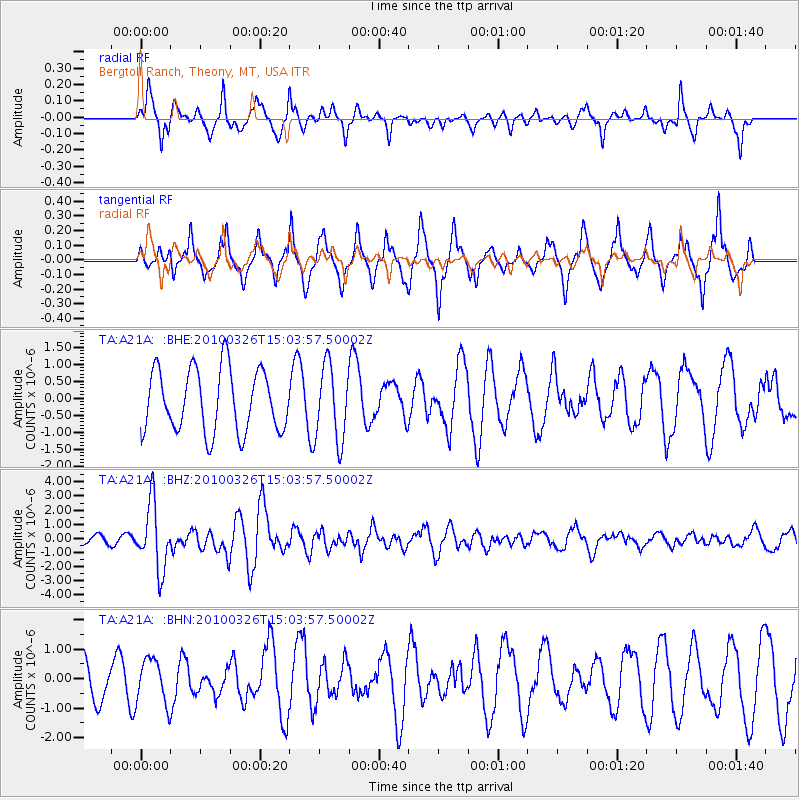
A21A Bergtoll Ranch, Theony, MT, USA - Earthquake Result Viewer
*The percent match for this event was below the threshold and hence no stack was calculated.
| Earthquake location: |
Near Coast Of Northern Chile |
| Earthquake latitude/longitude: |
-28.0/-70.8 |
| Earthquake time(UTC): |
2010/03/26 (085) 14:52:07 GMT |
| Earthquake Depth: |
42 km |
| Earthquake Magnitude: |
6.2 MB, 5.9 MS, 6.3 MW, 6.1 MW |
| Earthquake Catalog/Contributor: |
WHDF/NEIC |
|
| Network: |
TA USArray Transportable Network (new EarthScope stations) |
| Station: |
A21A Bergtoll Ranch, Theony, MT, USA |
| Lat/Lon: |
48.99 N/106.93 W |
| Elevation: |
779 m |
|
| Distance: |
83.1 deg |
| Az: |
336.986 deg |
| Baz: |
148.327 deg |
| Ray Param: |
$rayparam |
*The percent match for this event was below the threshold and hence was not used in the summary stack. |
|
| Radial Match: |
64.61996 % |
| Radial Bump: |
333 |
| Transverse Match: |
69.392746 % |
| Transverse Bump: |
319 |
| SOD ConfigId: |
312771 |
| Insert Time: |
2010-06-28 16:30:08.351 +0000 |
| GWidth: |
2.5 |
| Max Bumps: |
400 |
| Tol: |
0.001 |
|
Signal To Noise
| Channel | StoN | STA | LTA |
| TA:A21A: :BHZ:20100326T15:03:57.50002Z | 6.2353587 | 2.321417E-6 | 3.7229887E-7 |
| TA:A21A: :BHN:20100326T15:03:57.50002Z | 0.86846924 | 7.501071E-7 | 8.637118E-7 |
| TA:A21A: :BHE:20100326T15:03:57.50002Z | 1.2177134 | 1.1185009E-6 | 9.1852564E-7 |
| Arrivals |
| Ps | |
| PpPs | |
| PsPs/PpSs | |


