You are here: Home > Network List > TM - Thai Seismic Monitoring Network Stations List
> Station LOEI Nam Man, Loei > Earthquake Result Viewer
LOEI Nam Man, Loei - Earthquake Result Viewer
| Earthquake location: |
Tonga Islands |
| Earthquake latitude/longitude: |
-18.5/-175.2 |
| Earthquake time(UTC): |
2023/05/27 (147) 00:11:00 GMT |
| Earthquake Depth: |
215 km |
| Earthquake Magnitude: |
6.0 mww |
| Earthquake Catalog/Contributor: |
NEIC PDE/us |
|
| Network: |
TM Thai Seismic Monitoring Network |
| Station: |
LOEI Nam Man, Loei |
| Lat/Lon: |
17.51 N/101.62 E |
| Elevation: |
305 m |
|
| Distance: |
89.2 deg |
| Az: |
288.635 deg |
| Baz: |
109.514 deg |
| Ray Param: |
0.041729245 |
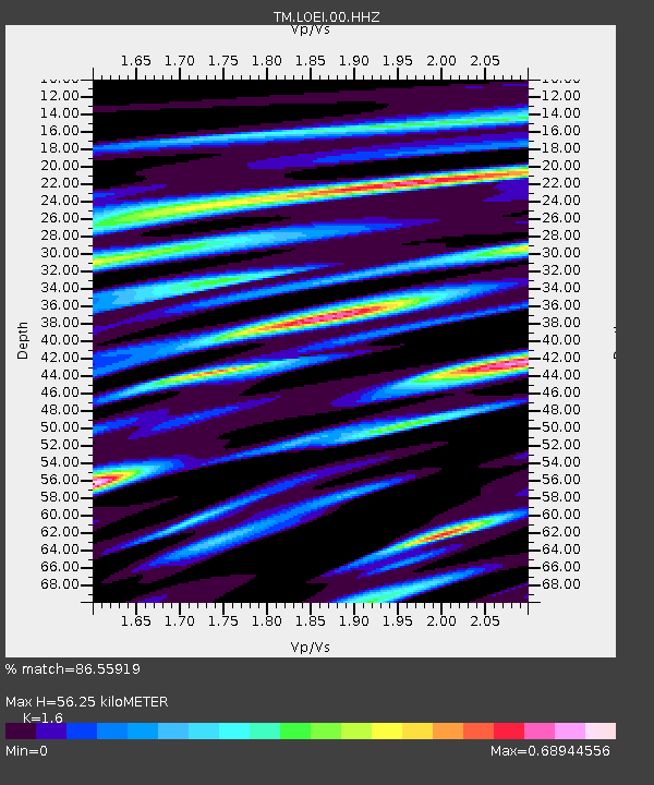
| Estimated Moho Depth: |
56.25 km |
| Estimated Crust Vp/Vs: |
1.60 |
| Assumed Crust Vp: |
6.35 km/s |
| Estimated Crust Vs: |
3.969 km/s |
| Estimated Crust Poisson's Ratio: |
0.18 |
|
| Radial Match: |
86.55919 % |
| Radial Bump: |
400 |
| Transverse Match: |
70.86238 % |
| Transverse Bump: |
400 |
| SOD ConfigId: |
30536071 |
| Insert Time: |
2023-06-10 00:38:24.799 +0000 |
| GWidth: |
2.5 |
| Max Bumps: |
400 |
| Tol: |
0.001 |
|

Signal To Noise
| Channel | StoN | STA | LTA |
| TM:LOEI:00:HHZ:20230527T00:23:00.480023Z | 11.483481 | 8.409027E-7 | 7.3227156E-8 |
| TM:LOEI:00:HHN:20230527T00:23:00.480023Z | 0.98453164 | 7.000989E-8 | 7.1109845E-8 |
| TM:LOEI:00:HHE:20230527T00:23:00.480023Z | 4.734711 | 2.801471E-7 | 5.9168787E-8 |
| Arrivals |
| Ps | 5.4 SECOND |
| PpPs | 23 SECOND |
| PsPs/PpSs | 28 SECOND |


