You are here: Home > Network List > TA - USArray Transportable Network (new EarthScope stations) Stations List
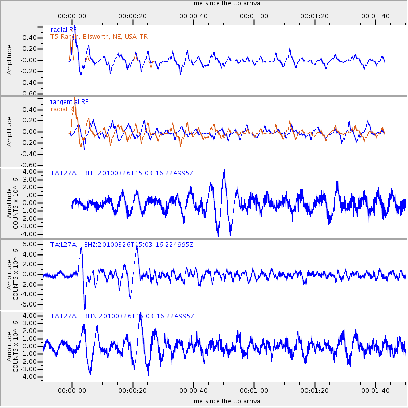
> Station L27A T5 Ranch, Ellsworth, NE, USA > Earthquake Result Viewer
L27A T5 Ranch, Ellsworth, NE, USA - Earthquake Result Viewer
| Earthquake location: |
Near Coast Of Northern Chile |
| Earthquake latitude/longitude: |
-28.0/-70.8 |
| Earthquake time(UTC): |
2010/03/26 (085) 14:52:07 GMT |
| Earthquake Depth: |
42 km |
| Earthquake Magnitude: |
6.2 MB, 5.9 MS, 6.3 MW, 6.1 MW |
| Earthquake Catalog/Contributor: |
WHDF/NEIC |
|
| Network: |
TA USArray Transportable Network (new EarthScope stations) |
| Station: |
L27A T5 Ranch, Ellsworth, NE, USA |
| Lat/Lon: |
42.08 N/102.32 W |
| Elevation: |
1186 m |
|
| Distance: |
75.5 deg |
| Az: |
336.318 deg |
| Baz: |
151.489 deg |
| Ray Param: |
0.051546726 |
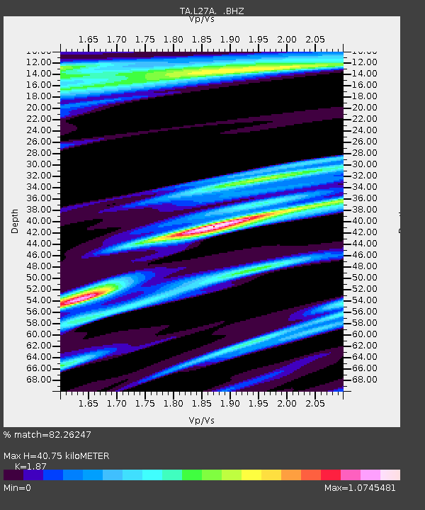
| Estimated Moho Depth: |
40.75 km |
| Estimated Crust Vp/Vs: |
1.87 |
| Assumed Crust Vp: |
6.483 km/s |
| Estimated Crust Vs: |
3.467 km/s |
| Estimated Crust Poisson's Ratio: |
0.30 |
|
| Radial Match: |
82.26247 % |
| Radial Bump: |
361 |
| Transverse Match: |
71.86052 % |
| Transverse Bump: |
356 |
| SOD ConfigId: |
312771 |
| Insert Time: |
2010-06-28 16:32:49.929 +0000 |
| GWidth: |
2.5 |
| Max Bumps: |
400 |
| Tol: |
0.001 |
|
Signal To Noise
| Channel | StoN | STA | LTA |
| TA:L27A: :BHZ:20100326T15:03:16.224995Z | 8.742614 | 2.9382795E-6 | 3.3608708E-7 |
| TA:L27A: :BHN:20100326T15:03:16.224995Z | 1.8337729 | 1.2489938E-6 | 6.811061E-7 |
| TA:L27A: :BHE:20100326T15:03:16.224995Z | 1.0142382 | 7.4458075E-7 | 7.34128E-7 |
| Arrivals |
| Ps | 5.6 SECOND |
| PpPs | 17 SECOND |
| PsPs/PpSs | 23 SECOND |


