You are here: Home > Network List > TA - USArray Transportable Network (new EarthScope stations) Stations List
> Station T26A Comanche National Grassland Park, Kim, CO, USA > Earthquake Result Viewer
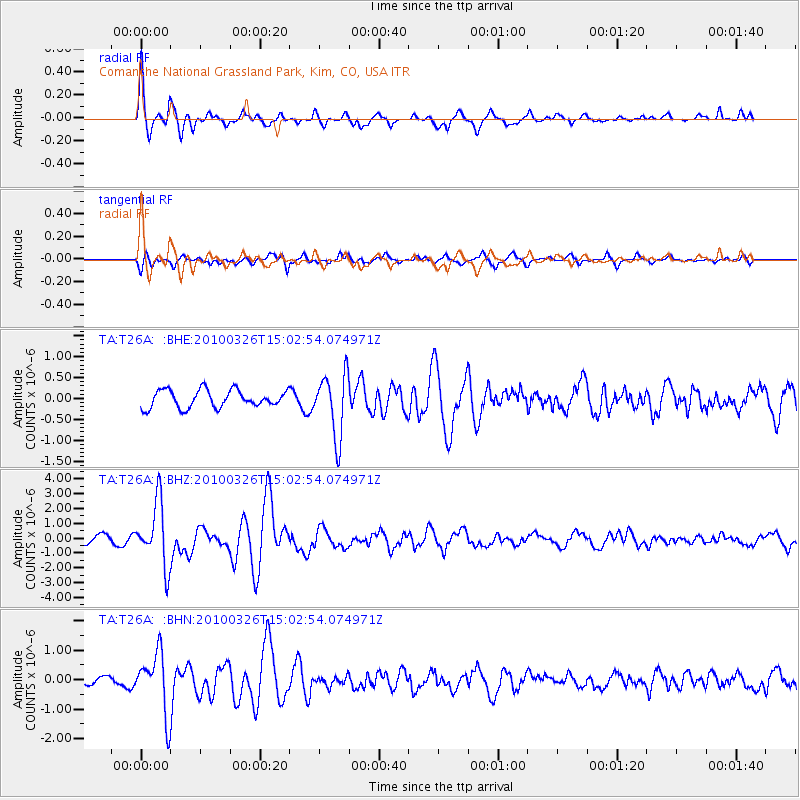
T26A Comanche National Grassland Park, Kim, CO, USA - Earthquake Result Viewer
*The percent match for this event was below the threshold and hence no stack was calculated.
| Earthquake location: |
Near Coast Of Northern Chile |
| Earthquake latitude/longitude: |
-28.0/-70.8 |
| Earthquake time(UTC): |
2010/03/26 (085) 14:52:07 GMT |
| Earthquake Depth: |
42 km |
| Earthquake Magnitude: |
6.2 MB, 5.9 MS, 6.3 MW, 6.1 MW |
| Earthquake Catalog/Contributor: |
WHDF/NEIC |
|
| Network: |
TA USArray Transportable Network (new EarthScope stations) |
| Station: |
T26A Comanche National Grassland Park, Kim, CO, USA |
| Lat/Lon: |
37.17 N/103.59 W |
| Elevation: |
1830 m |
|
| Distance: |
71.7 deg |
| Az: |
332.914 deg |
| Baz: |
149.716 deg |
| Ray Param: |
$rayparam |
*The percent match for this event was below the threshold and hence was not used in the summary stack. |
|
| Radial Match: |
79.52332 % |
| Radial Bump: |
336 |
| Transverse Match: |
48.854813 % |
| Transverse Bump: |
358 |
| SOD ConfigId: |
312771 |
| Insert Time: |
2010-06-28 16:33:55.298 +0000 |
| GWidth: |
2.5 |
| Max Bumps: |
400 |
| Tol: |
0.001 |
|
Signal To Noise
| Channel | StoN | STA | LTA |
| TA:T26A: :BHZ:20100326T15:02:54.074971Z | 6.8698177 | 2.131826E-6 | 3.1031772E-7 |
| TA:T26A: :BHN:20100326T15:02:54.074971Z | 4.8558908 | 1.0255078E-6 | 2.1118841E-7 |
| TA:T26A: :BHE:20100326T15:02:54.074971Z | 3.6123223 | 7.5506597E-7 | 2.0902509E-7 |
| Arrivals |
| Ps | |
| PpPs | |
| PsPs/PpSs | |


