You are here: Home > Network List > TA - USArray Transportable Network (new EarthScope stations) Stations List
> Station 430A Baggett Ranch, Ozona, TX, USA > Earthquake Result Viewer
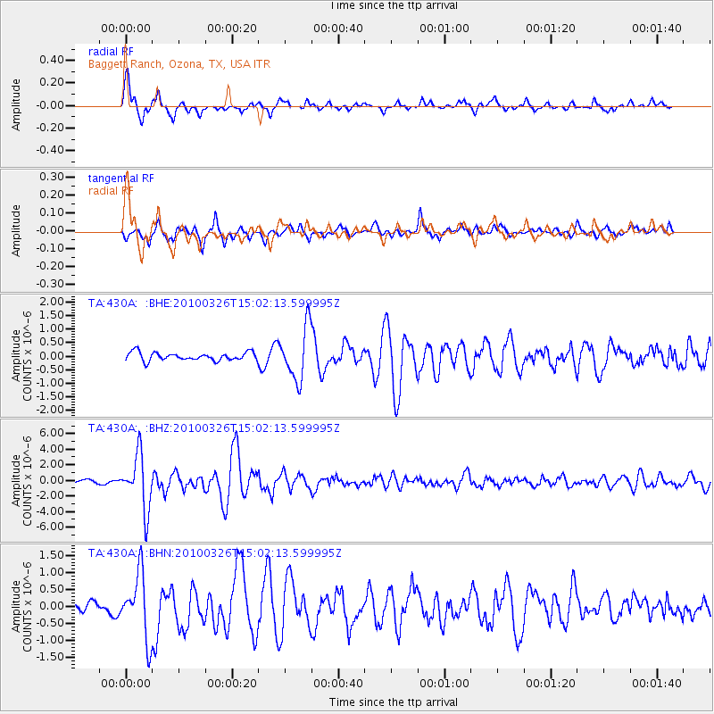
430A Baggett Ranch, Ozona, TX, USA - Earthquake Result Viewer
| Earthquake location: |
Near Coast Of Northern Chile |
| Earthquake latitude/longitude: |
-28.0/-70.8 |
| Earthquake time(UTC): |
2010/03/26 (085) 14:52:07 GMT |
| Earthquake Depth: |
42 km |
| Earthquake Magnitude: |
6.2 MB, 5.9 MS, 6.3 MW, 6.1 MW |
| Earthquake Catalog/Contributor: |
WHDF/NEIC |
|
| Network: |
TA USArray Transportable Network (new EarthScope stations) |
| Station: |
430A Baggett Ranch, Ozona, TX, USA |
| Lat/Lon: |
30.79 N/101.24 W |
| Elevation: |
768 m |
|
| Distance: |
65.2 deg |
| Az: |
331.325 deg |
| Baz: |
150.446 deg |
| Ray Param: |
0.05833098 |
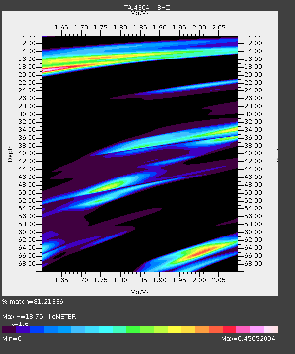
| Estimated Moho Depth: |
18.75 km |
| Estimated Crust Vp/Vs: |
1.60 |
| Assumed Crust Vp: |
6.38 km/s |
| Estimated Crust Vs: |
3.988 km/s |
| Estimated Crust Poisson's Ratio: |
0.18 |
|
| Radial Match: |
81.21336 % |
| Radial Bump: |
337 |
| Transverse Match: |
77.69415 % |
| Transverse Bump: |
400 |
| SOD ConfigId: |
312771 |
| Insert Time: |
2010-06-28 16:35:41.195 +0000 |
| GWidth: |
2.5 |
| Max Bumps: |
400 |
| Tol: |
0.001 |
|
Signal To Noise
| Channel | StoN | STA | LTA |
| TA:430A: :BHZ:20100326T15:02:13.599995Z | 14.909119 | 3.5389362E-6 | 2.3736723E-7 |
| TA:430A: :BHN:20100326T15:02:13.599995Z | 5.363489 | 9.549815E-7 | 1.7805228E-7 |
| TA:430A: :BHE:20100326T15:02:13.599995Z | 6.506213 | 9.742251E-7 | 1.4973767E-7 |
| Arrivals |
| Ps | 1.8 SECOND |
| PpPs | 7.3 SECOND |
| PsPs/PpSs | 9.1 SECOND |


