You are here: Home > Network List > TA - USArray Transportable Network (new EarthScope stations) Stations List
> Station 230A Sterling City, TX, USA > Earthquake Result Viewer
230A Sterling City, TX, USA - Earthquake Result Viewer
| Earthquake location: |
Near Coast Of Northern Chile |
| Earthquake latitude/longitude: |
-28.0/-70.8 |
| Earthquake time(UTC): |
2010/03/26 (085) 14:52:07 GMT |
| Earthquake Depth: |
42 km |
| Earthquake Magnitude: |
6.2 MB, 5.9 MS, 6.3 MW, 6.1 MW |
| Earthquake Catalog/Contributor: |
WHDF/NEIC |
|
| Network: |
TA USArray Transportable Network (new EarthScope stations) |
| Station: |
230A Sterling City, TX, USA |
| Lat/Lon: |
31.89 N/101.11 W |
| Elevation: |
742 m |
|
| Distance: |
66.1 deg |
| Az: |
332.017 deg |
| Baz: |
150.795 deg |
| Ray Param: |
0.057738613 |
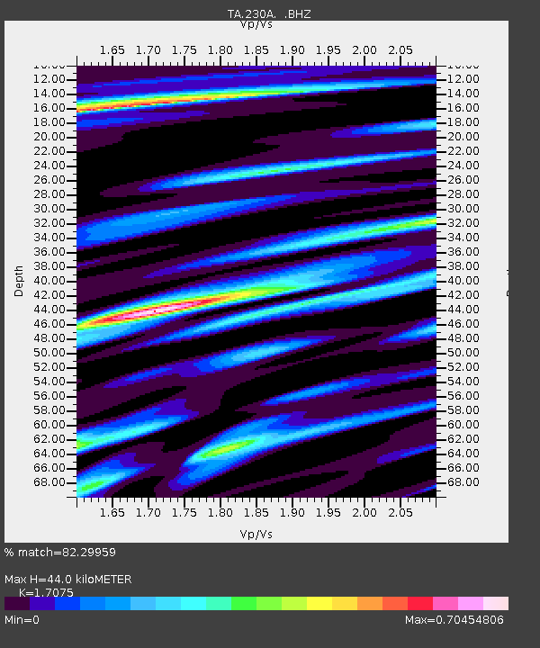
| Estimated Moho Depth: |
44.0 km |
| Estimated Crust Vp/Vs: |
1.71 |
| Assumed Crust Vp: |
6.38 km/s |
| Estimated Crust Vs: |
3.737 km/s |
| Estimated Crust Poisson's Ratio: |
0.24 |
|
| Radial Match: |
82.29959 % |
| Radial Bump: |
400 |
| Transverse Match: |
77.39256 % |
| Transverse Bump: |
400 |
| SOD ConfigId: |
312771 |
| Insert Time: |
2010-06-28 16:36:29.788 +0000 |
| GWidth: |
2.5 |
| Max Bumps: |
400 |
| Tol: |
0.001 |
|
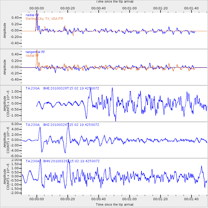
Signal To Noise
| Channel | StoN | STA | LTA |
| TA:230A: :BHZ:20100326T15:02:19.425007Z | 14.341758 | 2.5501308E-6 | 1.778116E-7 |
| TA:230A: :BHN:20100326T15:02:19.425007Z | 2.920807 | 1.018908E-6 | 3.488447E-7 |
| TA:230A: :BHE:20100326T15:02:19.425007Z | 4.7263637 | 6.6699965E-7 | 1.4112322E-7 |
| Arrivals |
| Ps | 5.1 SECOND |
| PpPs | 18 SECOND |
| PsPs/PpSs | 23 SECOND |


