You are here: Home > Network List > TA - USArray Transportable Network (new EarthScope stations) Stations List
> Station 330A Mertzon, TX, USA > Earthquake Result Viewer
330A Mertzon, TX, USA - Earthquake Result Viewer
| Earthquake location: |
Near Coast Of Northern Chile |
| Earthquake latitude/longitude: |
-28.0/-70.8 |
| Earthquake time(UTC): |
2010/03/26 (085) 14:52:07 GMT |
| Earthquake Depth: |
42 km |
| Earthquake Magnitude: |
6.2 MB, 5.9 MS, 6.3 MW, 6.1 MW |
| Earthquake Catalog/Contributor: |
WHDF/NEIC |
|
| Network: |
TA USArray Transportable Network (new EarthScope stations) |
| Station: |
330A Mertzon, TX, USA |
| Lat/Lon: |
31.41 N/101.18 W |
| Elevation: |
742 m |
|
| Distance: |
65.7 deg |
| Az: |
331.709 deg |
| Baz: |
150.636 deg |
| Ray Param: |
0.05799517 |
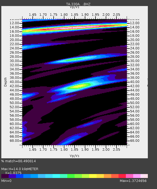
| Estimated Moho Depth: |
14.0 km |
| Estimated Crust Vp/Vs: |
1.84 |
| Assumed Crust Vp: |
6.38 km/s |
| Estimated Crust Vs: |
3.472 km/s |
| Estimated Crust Poisson's Ratio: |
0.29 |
|
| Radial Match: |
88.490814 % |
| Radial Bump: |
400 |
| Transverse Match: |
68.60133 % |
| Transverse Bump: |
400 |
| SOD ConfigId: |
312771 |
| Insert Time: |
2010-06-28 16:36:34.454 +0000 |
| GWidth: |
2.5 |
| Max Bumps: |
400 |
| Tol: |
0.001 |
|

Signal To Noise
| Channel | StoN | STA | LTA |
| TA:330A: :BHZ:20100326T15:02:16.899983Z | 14.805394 | 3.0906667E-6 | 2.0875275E-7 |
| TA:330A: :BHN:20100326T15:02:16.899983Z | 5.680945 | 9.791893E-7 | 1.723638E-7 |
| TA:330A: :BHE:20100326T15:02:16.899983Z | 3.3172085 | 5.1379436E-7 | 1.5488756E-7 |
| Arrivals |
| Ps | 1.9 SECOND |
| PpPs | 6.0 SECOND |
| PsPs/PpSs | 7.9 SECOND |


