You are here: Home > Network List > TA - USArray Transportable Network (new EarthScope stations) Stations List
> Station S30A Montezuma, KS, USA > Earthquake Result Viewer
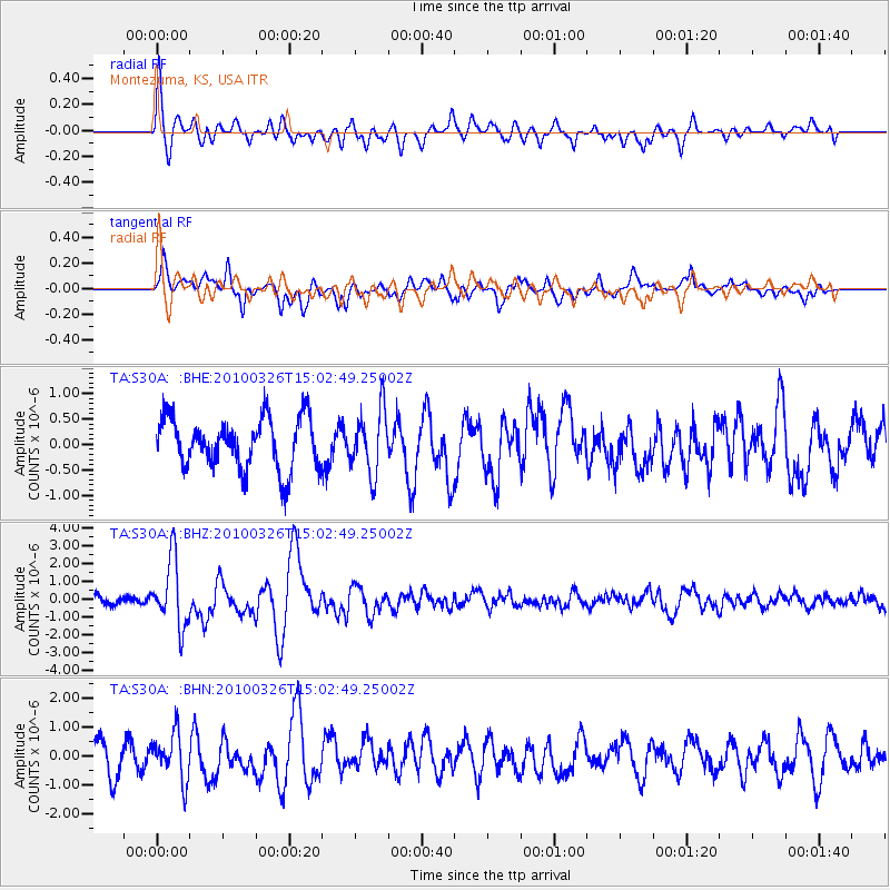
S30A Montezuma, KS, USA - Earthquake Result Viewer
*The percent match for this event was below the threshold and hence no stack was calculated.
| Earthquake location: |
Near Coast Of Northern Chile |
| Earthquake latitude/longitude: |
-28.0/-70.8 |
| Earthquake time(UTC): |
2010/03/26 (085) 14:52:07 GMT |
| Earthquake Depth: |
42 km |
| Earthquake Magnitude: |
6.2 MB, 5.9 MS, 6.3 MW, 6.1 MW |
| Earthquake Catalog/Contributor: |
WHDF/NEIC |
|
| Network: |
TA USArray Transportable Network (new EarthScope stations) |
| Station: |
S30A Montezuma, KS, USA |
| Lat/Lon: |
37.64 N/100.46 W |
| Elevation: |
853 m |
|
| Distance: |
70.9 deg |
| Az: |
335.453 deg |
| Baz: |
152.422 deg |
| Ray Param: |
$rayparam |
*The percent match for this event was below the threshold and hence was not used in the summary stack. |
|
| Radial Match: |
69.44041 % |
| Radial Bump: |
400 |
| Transverse Match: |
68.86834 % |
| Transverse Bump: |
351 |
| SOD ConfigId: |
312771 |
| Insert Time: |
2010-06-28 16:39:16.893 +0000 |
| GWidth: |
2.5 |
| Max Bumps: |
400 |
| Tol: |
0.001 |
|
Signal To Noise
| Channel | StoN | STA | LTA |
| TA:S30A: :BHZ:20100326T15:02:49.25002Z | 7.994293 | 1.8554358E-6 | 2.3209503E-7 |
| TA:S30A: :BHN:20100326T15:02:49.25002Z | 1.5196509 | 8.149568E-7 | 5.36279E-7 |
| TA:S30A: :BHE:20100326T15:02:49.25002Z | 1.2480217 | 6.1612775E-7 | 4.936835E-7 |
| Arrivals |
| Ps | |
| PpPs | |
| PsPs/PpSs | |


