You are here: Home > Network List > UU - University of Utah Regional Network Stations List
> Station CCUT Cedar City, UT, USA > Earthquake Result Viewer
CCUT Cedar City, UT, USA - Earthquake Result Viewer
*The percent match for this event was below the threshold and hence no stack was calculated.
| Earthquake location: |
Solomon Islands |
| Earthquake latitude/longitude: |
-10.1/161.2 |
| Earthquake time(UTC): |
2023/05/28 (148) 03:29:55 GMT |
| Earthquake Depth: |
104 km |
| Earthquake Magnitude: |
5.6 mww |
| Earthquake Catalog/Contributor: |
NEIC PDE/us |
|
| Network: |
UU University of Utah Regional Network |
| Station: |
CCUT Cedar City, UT, USA |
| Lat/Lon: |
37.55 N/113.36 W |
| Elevation: |
2127 m |
|
| Distance: |
92.5 deg |
| Az: |
52.471 deg |
| Baz: |
259.234 deg |
| Ray Param: |
$rayparam |
*The percent match for this event was below the threshold and hence was not used in the summary stack. |
|
| Radial Match: |
44.752064 % |
| Radial Bump: |
400 |
| Transverse Match: |
69.76229 % |
| Transverse Bump: |
345 |
| SOD ConfigId: |
30536071 |
| Insert Time: |
2023-06-11 03:50:21.424 +0000 |
| GWidth: |
2.5 |
| Max Bumps: |
400 |
| Tol: |
0.001 |
|
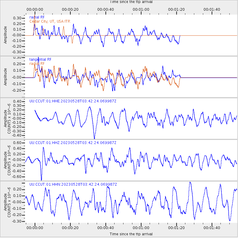
Signal To Noise
| Channel | StoN | STA | LTA |
| UU:CCUT:01:HHZ:20230528T03:42:24.069987Z | 3.3155758 | 2.4475412E-7 | 7.3819486E-8 |
| UU:CCUT:01:HHN:20230528T03:42:24.069987Z | 0.64944124 | 6.882961E-8 | 1.0598282E-7 |
| UU:CCUT:01:HHE:20230528T03:42:24.069987Z | 2.6790211 | 2.4395692E-7 | 9.106197E-8 |
| Arrivals |
| Ps | |
| PpPs | |
| PsPs/PpSs | |


