You are here: Home > Network List > TA - USArray Transportable Network (new EarthScope stations) Stations List
> Station P29A Atwood, KS, USA > Earthquake Result Viewer
P29A Atwood, KS, USA - Earthquake Result Viewer
| Earthquake location: |
Near Coast Of Northern Chile |
| Earthquake latitude/longitude: |
-28.0/-70.8 |
| Earthquake time(UTC): |
2010/03/26 (085) 14:52:07 GMT |
| Earthquake Depth: |
42 km |
| Earthquake Magnitude: |
6.2 MB, 5.9 MS, 6.3 MW, 6.1 MW |
| Earthquake Catalog/Contributor: |
WHDF/NEIC |
|
| Network: |
TA USArray Transportable Network (new EarthScope stations) |
| Station: |
P29A Atwood, KS, USA |
| Lat/Lon: |
39.60 N/100.93 W |
| Elevation: |
929 m |
|
| Distance: |
72.8 deg |
| Az: |
336.068 deg |
| Baz: |
152.323 deg |
| Ray Param: |
0.053329714 |
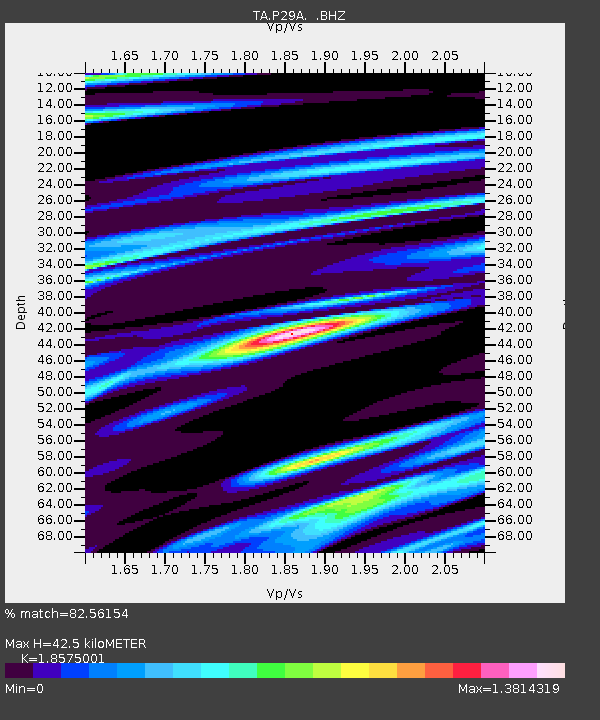
| Estimated Moho Depth: |
42.5 km |
| Estimated Crust Vp/Vs: |
1.86 |
| Assumed Crust Vp: |
6.483 km/s |
| Estimated Crust Vs: |
3.49 km/s |
| Estimated Crust Poisson's Ratio: |
0.30 |
|
| Radial Match: |
82.56154 % |
| Radial Bump: |
400 |
| Transverse Match: |
75.75438 % |
| Transverse Bump: |
387 |
| SOD ConfigId: |
312771 |
| Insert Time: |
2010-06-28 16:40:06.016 +0000 |
| GWidth: |
2.5 |
| Max Bumps: |
400 |
| Tol: |
0.001 |
|

Signal To Noise
| Channel | StoN | STA | LTA |
| TA:P29A: :BHZ:20100326T15:03:00.649983Z | 7.136136 | 2.3399375E-6 | 3.278998E-7 |
| TA:P29A: :BHN:20100326T15:03:00.649983Z | 3.5299447 | 1.0257851E-6 | 2.905952E-7 |
| TA:P29A: :BHE:20100326T15:03:00.649983Z | 2.0718951 | 7.7168244E-7 | 3.7245246E-7 |
| Arrivals |
| Ps | 5.8 SECOND |
| PpPs | 18 SECOND |
| PsPs/PpSs | 24 SECOND |


