You are here: Home > Network List > TA - USArray Transportable Network (new EarthScope stations) Stations List
> Station Q30A Quinter, KS, USA > Earthquake Result Viewer
Q30A Quinter, KS, USA - Earthquake Result Viewer
| Earthquake location: |
Near Coast Of Northern Chile |
| Earthquake latitude/longitude: |
-28.0/-70.8 |
| Earthquake time(UTC): |
2010/03/26 (085) 14:52:07 GMT |
| Earthquake Depth: |
42 km |
| Earthquake Magnitude: |
6.2 MB, 5.9 MS, 6.3 MW, 6.1 MW |
| Earthquake Catalog/Contributor: |
WHDF/NEIC |
|
| Network: |
TA USArray Transportable Network (new EarthScope stations) |
| Station: |
Q30A Quinter, KS, USA |
| Lat/Lon: |
38.98 N/100.22 W |
| Elevation: |
797 m |
|
| Distance: |
72.0 deg |
| Az: |
336.28 deg |
| Baz: |
152.835 deg |
| Ray Param: |
0.05386221 |
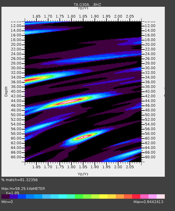
| Estimated Moho Depth: |
59.25 km |
| Estimated Crust Vp/Vs: |
1.85 |
| Assumed Crust Vp: |
6.483 km/s |
| Estimated Crust Vs: |
3.504 km/s |
| Estimated Crust Poisson's Ratio: |
0.29 |
|
| Radial Match: |
91.32356 % |
| Radial Bump: |
382 |
| Transverse Match: |
69.782326 % |
| Transverse Bump: |
400 |
| SOD ConfigId: |
312771 |
| Insert Time: |
2010-06-28 16:40:06.151 +0000 |
| GWidth: |
2.5 |
| Max Bumps: |
400 |
| Tol: |
0.001 |
|

Signal To Noise
| Channel | StoN | STA | LTA |
| TA:Q30A: :BHZ:20100326T15:02:55.849995Z | 13.416301 | 2.5057439E-6 | 1.867686E-7 |
| TA:Q30A: :BHN:20100326T15:02:55.849995Z | 4.37808 | 1.3927312E-6 | 3.181146E-7 |
| TA:Q30A: :BHE:20100326T15:02:55.849995Z | 2.1565678 | 8.763065E-7 | 4.0634313E-7 |
| Arrivals |
| Ps | 8.0 SECOND |
| PpPs | 25 SECOND |
| PsPs/PpSs | 33 SECOND |


