You are here: Home > Network List > CI - Caltech Regional Seismic Network Stations List
> Station SWS Sam W. Stewart, Westmorland, CA, USA > Earthquake Result Viewer
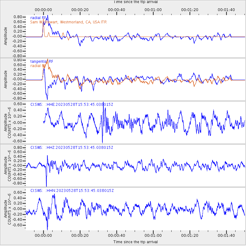
SWS Sam W. Stewart, Westmorland, CA, USA - Earthquake Result Viewer
*The percent match for this event was below the threshold and hence no stack was calculated.
| Earthquake location: |
Northern Colombia |
| Earthquake latitude/longitude: |
6.7/-73.0 |
| Earthquake time(UTC): |
2023/05/28 (148) 15:45:56 GMT |
| Earthquake Depth: |
158 km |
| Earthquake Magnitude: |
5.3 Mww |
| Earthquake Catalog/Contributor: |
NEIC PDE/us |
|
| Network: |
CI Caltech Regional Seismic Network |
| Station: |
SWS Sam W. Stewart, Westmorland, CA, USA |
| Lat/Lon: |
32.94 N/115.80 W |
| Elevation: |
140 m |
|
| Distance: |
47.5 deg |
| Az: |
309.198 deg |
| Baz: |
113.745 deg |
| Ray Param: |
$rayparam |
*The percent match for this event was below the threshold and hence was not used in the summary stack. |
|
| Radial Match: |
57.389877 % |
| Radial Bump: |
400 |
| Transverse Match: |
63.490685 % |
| Transverse Bump: |
400 |
| SOD ConfigId: |
30536071 |
| Insert Time: |
2023-06-11 15:56:20.279 +0000 |
| GWidth: |
2.5 |
| Max Bumps: |
400 |
| Tol: |
0.001 |
|
Signal To Noise
| Channel | StoN | STA | LTA |
| CI:SWS: :HHZ:20230528T15:53:45.038015Z | 2.604917 | 2.389102E-7 | 9.171508E-8 |
| CI:SWS: :HHN:20230528T15:53:45.038015Z | 1.5857124 | 2.5494822E-7 | 1.6077834E-7 |
| CI:SWS: :HHE:20230528T15:53:45.038015Z | 1.5388056 | 2.8492585E-7 | 1.8516039E-7 |
| Arrivals |
| Ps | |
| PpPs | |
| PsPs/PpSs | |


