You are here: Home > Network List > GM - US Geological Survey Networks Stations List
> Station IWM01 Jericho 2M Well Monitoring Station > Earthquake Result Viewer
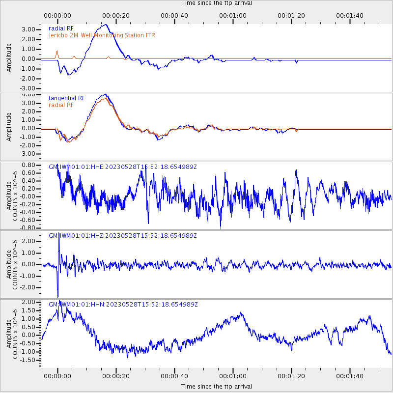
IWM01 Jericho 2M Well Monitoring Station - Earthquake Result Viewer
*The percent match for this event was below the threshold and hence no stack was calculated.
| Earthquake location: |
Northern Colombia |
| Earthquake latitude/longitude: |
6.7/-73.0 |
| Earthquake time(UTC): |
2023/05/28 (148) 15:45:56 GMT |
| Earthquake Depth: |
158 km |
| Earthquake Magnitude: |
5.3 Mww |
| Earthquake Catalog/Contributor: |
NEIC PDE/us |
|
| Network: |
GM US Geological Survey Networks |
| Station: |
IWM01 Jericho 2M Well Monitoring Station |
| Lat/Lon: |
36.73 N/96.53 W |
| Elevation: |
328 m |
|
| Distance: |
36.8 deg |
| Az: |
327.632 deg |
| Baz: |
138.56 deg |
| Ray Param: |
$rayparam |
*The percent match for this event was below the threshold and hence was not used in the summary stack. |
|
| Radial Match: |
52.49984 % |
| Radial Bump: |
400 |
| Transverse Match: |
49.766407 % |
| Transverse Bump: |
400 |
| SOD ConfigId: |
30536071 |
| Insert Time: |
2023-06-11 16:00:12.651 +0000 |
| GWidth: |
2.5 |
| Max Bumps: |
400 |
| Tol: |
0.001 |
|
Signal To Noise
| Channel | StoN | STA | LTA |
| GM:IWM01:01:HHZ:20230528T15:52:18.654989Z | 4.9360204 | 8.7005697E-7 | 1.762669E-7 |
| GM:IWM01:01:HHN:20230528T15:52:18.654989Z | 0.7870181 | 1.0174099E-6 | 1.2927401E-6 |
| GM:IWM01:01:HHE:20230528T15:52:18.654989Z | 1.4189721 | 3.713921E-7 | 2.617332E-7 |
| Arrivals |
| Ps | |
| PpPs | |
| PsPs/PpSs | |


