You are here: Home > Network List > IU - Global Seismograph Network (GSN - IRIS/USGS) Stations List
> Station RSSD Black Hills, South Dakota, USA > Earthquake Result Viewer
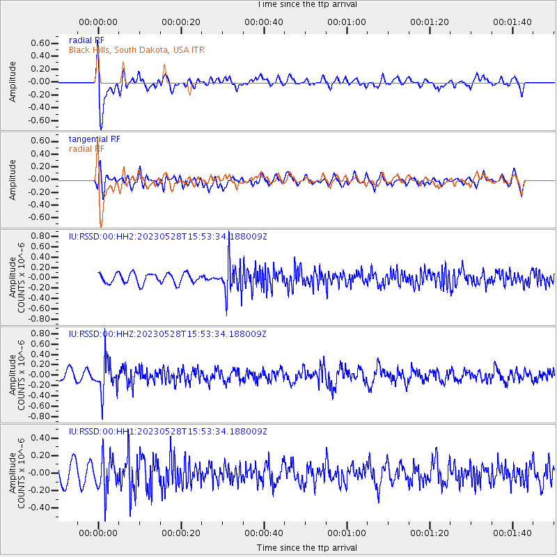
RSSD Black Hills, South Dakota, USA - Earthquake Result Viewer
*The percent match for this event was below the threshold and hence no stack was calculated.
| Earthquake location: |
Northern Colombia |
| Earthquake latitude/longitude: |
6.7/-73.0 |
| Earthquake time(UTC): |
2023/05/28 (148) 15:45:56 GMT |
| Earthquake Depth: |
158 km |
| Earthquake Magnitude: |
5.3 Mww |
| Earthquake Catalog/Contributor: |
NEIC PDE/us |
|
| Network: |
IU Global Seismograph Network (GSN - IRIS/USGS) |
| Station: |
RSSD Black Hills, South Dakota, USA |
| Lat/Lon: |
44.12 N/104.04 W |
| Elevation: |
2090 m |
|
| Distance: |
46.1 deg |
| Az: |
328.985 deg |
| Baz: |
134.717 deg |
| Ray Param: |
$rayparam |
*The percent match for this event was below the threshold and hence was not used in the summary stack. |
|
| Radial Match: |
68.419106 % |
| Radial Bump: |
400 |
| Transverse Match: |
58.289303 % |
| Transverse Bump: |
400 |
| SOD ConfigId: |
30536071 |
| Insert Time: |
2023-06-11 16:02:01.155 +0000 |
| GWidth: |
2.5 |
| Max Bumps: |
400 |
| Tol: |
0.001 |
|
Signal To Noise
| Channel | StoN | STA | LTA |
| IU:RSSD:00:HHZ:20230528T15:53:34.188009Z | 4.5289097 | 3.1540665E-7 | 6.964295E-8 |
| IU:RSSD:00:HH1:20230528T15:53:34.188009Z | 2.0451236 | 1.9118924E-7 | 9.3485426E-8 |
| IU:RSSD:00:HH2:20230528T15:53:34.188009Z | 3.2007678 | 3.0805558E-7 | 9.624427E-8 |
| Arrivals |
| Ps | |
| PpPs | |
| PsPs/PpSs | |


