You are here: Home > Network List > TA - USArray Transportable Network (new EarthScope stations) Stations List
> Station F29A Eureka, SD, USA > Earthquake Result Viewer
F29A Eureka, SD, USA - Earthquake Result Viewer
| Earthquake location: |
Near Coast Of Northern Chile |
| Earthquake latitude/longitude: |
-28.0/-70.8 |
| Earthquake time(UTC): |
2010/03/26 (085) 14:52:07 GMT |
| Earthquake Depth: |
42 km |
| Earthquake Magnitude: |
6.2 MB, 5.9 MS, 6.3 MW, 6.1 MW |
| Earthquake Catalog/Contributor: |
WHDF/NEIC |
|
| Network: |
TA USArray Transportable Network (new EarthScope stations) |
| Station: |
F29A Eureka, SD, USA |
| Lat/Lon: |
45.83 N/99.83 W |
| Elevation: |
575 m |
|
| Distance: |
78.0 deg |
| Az: |
339.723 deg |
| Baz: |
153.991 deg |
| Ray Param: |
0.049854882 |
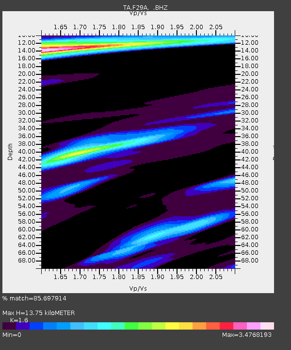
| Estimated Moho Depth: |
13.75 km |
| Estimated Crust Vp/Vs: |
1.60 |
| Assumed Crust Vp: |
6.53 km/s |
| Estimated Crust Vs: |
4.082 km/s |
| Estimated Crust Poisson's Ratio: |
0.18 |
|
| Radial Match: |
85.697914 % |
| Radial Bump: |
350 |
| Transverse Match: |
73.61423 % |
| Transverse Bump: |
386 |
| SOD ConfigId: |
312771 |
| Insert Time: |
2010-06-28 16:45:05.536 +0000 |
| GWidth: |
2.5 |
| Max Bumps: |
400 |
| Tol: |
0.001 |
|
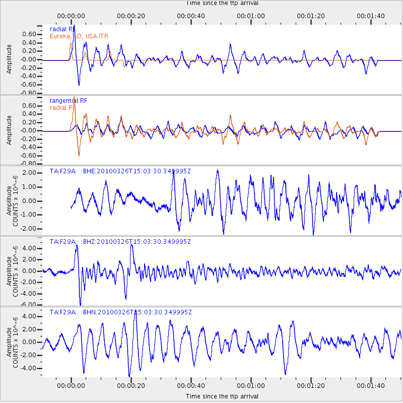
Signal To Noise
| Channel | StoN | STA | LTA |
| TA:F29A: :BHZ:20100326T15:03:30.349995Z | 9.786514 | 2.672652E-6 | 2.7309542E-7 |
| TA:F29A: :BHN:20100326T15:03:30.349995Z | 2.933863 | 2.1037924E-6 | 7.170725E-7 |
| TA:F29A: :BHE:20100326T15:03:30.349995Z | 1.6108065 | 8.193443E-7 | 5.086547E-7 |
| Arrivals |
| Ps | 1.3 SECOND |
| PpPs | 5.3 SECOND |
| PsPs/PpSs | 6.6 SECOND |


