You are here: Home > Network List > TA - USArray Transportable Network (new EarthScope stations) Stations List
> Station L30A Spencer Herefords Ranch, Brewster, NE, USA > Earthquake Result Viewer
L30A Spencer Herefords Ranch, Brewster, NE, USA - Earthquake Result Viewer
| Earthquake location: |
Near Coast Of Northern Chile |
| Earthquake latitude/longitude: |
-28.0/-70.8 |
| Earthquake time(UTC): |
2010/03/26 (085) 14:52:07 GMT |
| Earthquake Depth: |
42 km |
| Earthquake Magnitude: |
6.2 MB, 5.9 MS, 6.3 MW, 6.1 MW |
| Earthquake Catalog/Contributor: |
WHDF/NEIC |
|
| Network: |
TA USArray Transportable Network (new EarthScope stations) |
| Station: |
L30A Spencer Herefords Ranch, Brewster, NE, USA |
| Lat/Lon: |
41.95 N/99.72 W |
| Elevation: |
782 m |
|
| Distance: |
74.5 deg |
| Az: |
338.032 deg |
| Baz: |
153.664 deg |
| Ray Param: |
0.05221752 |
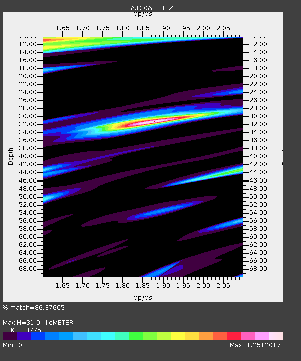
| Estimated Moho Depth: |
31.0 km |
| Estimated Crust Vp/Vs: |
1.88 |
| Assumed Crust Vp: |
6.53 km/s |
| Estimated Crust Vs: |
3.478 km/s |
| Estimated Crust Poisson's Ratio: |
0.30 |
|
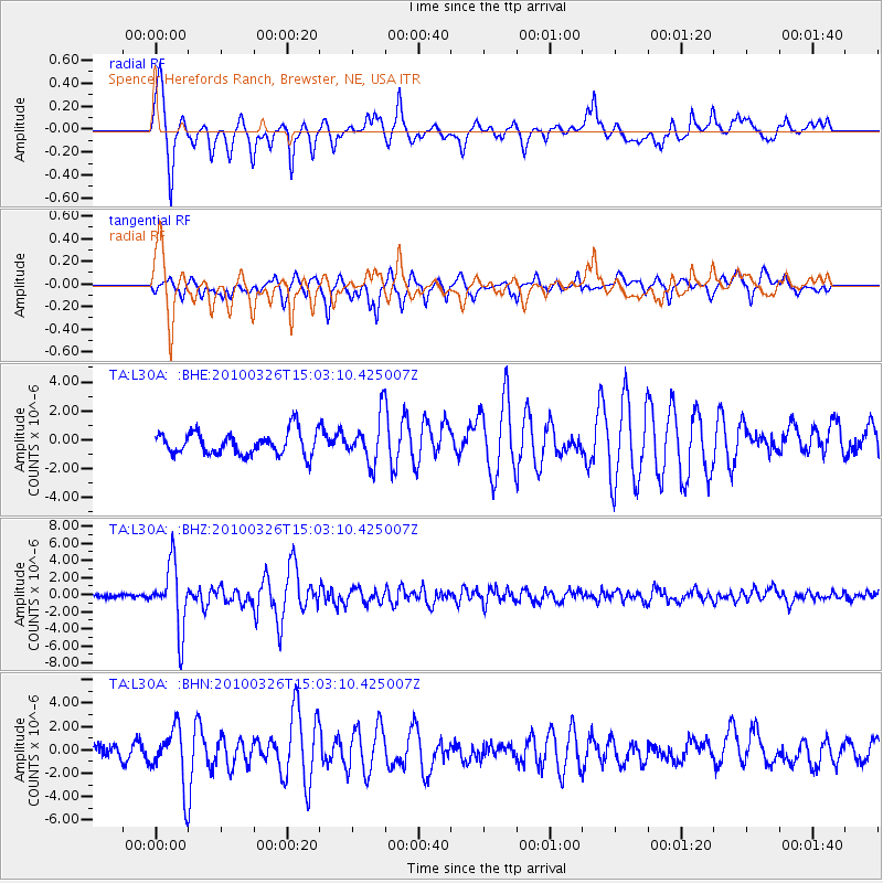
| Radial Match: |
86.37605 % |
| Radial Bump: |
387 |
| Transverse Match: |
84.26761 % |
| Transverse Bump: |
400 |
| SOD ConfigId: |
312771 |
| Insert Time: |
2010-06-28 16:45:16.216 +0000 |
| GWidth: |
2.5 |
| Max Bumps: |
400 |
| Tol: |
0.001 |
|
Signal To Noise
| Channel | StoN | STA | LTA |
| TA:L30A: :BHZ:20100326T15:03:10.425007Z | 18.312037 | 3.7931418E-6 | 2.0713927E-7 |
| TA:L30A: :BHN:20100326T15:03:10.425007Z | 3.6437128 | 2.400908E-6 | 6.58918E-7 |
| TA:L30A: :BHE:20100326T15:03:10.425007Z | 1.9552351 | 1.5700889E-6 | 8.0301794E-7 |
| Arrivals |
| Ps | 4.3 SECOND |
| PpPs | 13 SECOND |
| PsPs/PpSs | 18 SECOND |


