You are here: Home > Network List > NE - New England Seismic Network Stations List
> Station EMMW Machias, ME, USA > Earthquake Result Viewer
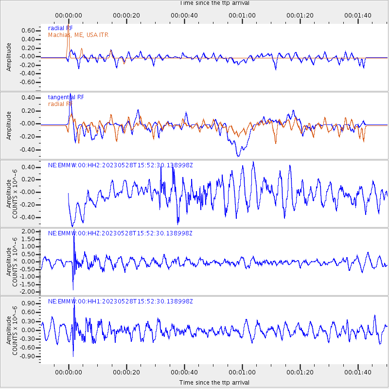
EMMW Machias, ME, USA - Earthquake Result Viewer
*The percent match for this event was below the threshold and hence no stack was calculated.
| Earthquake location: |
Northern Colombia |
| Earthquake latitude/longitude: |
6.7/-73.0 |
| Earthquake time(UTC): |
2023/05/28 (148) 15:45:56 GMT |
| Earthquake Depth: |
158 km |
| Earthquake Magnitude: |
5.3 Mww |
| Earthquake Catalog/Contributor: |
NEIC PDE/us |
|
| Network: |
NE New England Seismic Network |
| Station: |
EMMW Machias, ME, USA |
| Lat/Lon: |
44.71 N/67.46 W |
| Elevation: |
35 m |
|
| Distance: |
38.1 deg |
| Az: |
6.423 deg |
| Baz: |
188.965 deg |
| Ray Param: |
$rayparam |
*The percent match for this event was below the threshold and hence was not used in the summary stack. |
|
| Radial Match: |
64.37875 % |
| Radial Bump: |
400 |
| Transverse Match: |
57.018505 % |
| Transverse Bump: |
400 |
| SOD ConfigId: |
30536071 |
| Insert Time: |
2023-06-11 16:06:04.232 +0000 |
| GWidth: |
2.5 |
| Max Bumps: |
400 |
| Tol: |
0.001 |
|
Signal To Noise
| Channel | StoN | STA | LTA |
| NE:EMMW:00:HHZ:20230528T15:52:30.138998Z | 2.4765332 | 5.230983E-7 | 2.1122203E-7 |
| NE:EMMW:00:HH1:20230528T15:52:30.138998Z | 1.3592162 | 3.1112714E-7 | 2.2890188E-7 |
| NE:EMMW:00:HH2:20230528T15:52:30.138998Z | 0.85450244 | 1.541439E-7 | 1.8039024E-7 |
| Arrivals |
| Ps | |
| PpPs | |
| PsPs/PpSs | |


