You are here: Home > Network List > GS - US Geological Survey Networks Stations List
> Station KS21 NEIC Portable/Temp deployment > Earthquake Result Viewer
KS21 NEIC Portable/Temp deployment - Earthquake Result Viewer
| Earthquake location: |
Northern Chile |
| Earthquake latitude/longitude: |
-19.6/-69.3 |
| Earthquake time(UTC): |
2018/11/01 (305) 22:19:51 GMT |
| Earthquake Depth: |
102 km |
| Earthquake Magnitude: |
6.2 Mww |
| Earthquake Catalog/Contributor: |
NEIC PDE/us |
|
| Network: |
GS US Geological Survey Networks |
| Station: |
KS21 NEIC Portable/Temp deployment |
| Lat/Lon: |
37.29 N/97.66 W |
| Elevation: |
414 m |
|
| Distance: |
62.6 deg |
| Az: |
334.724 deg |
| Baz: |
149.685 deg |
| Ray Param: |
0.059858765 |
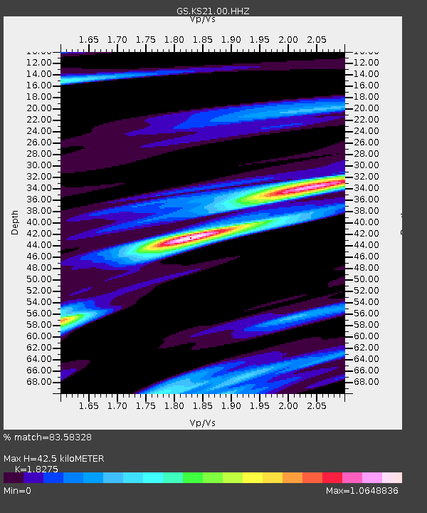
| Estimated Moho Depth: |
42.5 km |
| Estimated Crust Vp/Vs: |
1.83 |
| Assumed Crust Vp: |
6.483 km/s |
| Estimated Crust Vs: |
3.547 km/s |
| Estimated Crust Poisson's Ratio: |
0.29 |
|
| Radial Match: |
83.58328 % |
| Radial Bump: |
354 |
| Transverse Match: |
76.36924 % |
| Transverse Bump: |
400 |
| SOD ConfigId: |
3131071 |
| Insert Time: |
2018-11-15 22:25:21.197 +0000 |
| GWidth: |
2.5 |
| Max Bumps: |
400 |
| Tol: |
0.001 |
|

Signal To Noise
| Channel | StoN | STA | LTA |
| GS:KS21:00:HHZ:20181101T22:29:34.024009Z | 16.166525 | 3.1263298E-6 | 1.9338292E-7 |
| GS:KS21:00:HH1:20181101T22:29:34.024009Z | 4.679088 | 1.3987366E-6 | 2.9893357E-7 |
| GS:KS21:00:HH2:20181101T22:29:34.024009Z | 3.9433887 | 7.436413E-7 | 1.8857925E-7 |
| Arrivals |
| Ps | 5.7 SECOND |
| PpPs | 18 SECOND |
| PsPs/PpSs | 23 SECOND |


