You are here: Home > Network List > TA - USArray Transportable Network (new EarthScope stations) Stations List
> Station K30A Basset, NE, USA > Earthquake Result Viewer
K30A Basset, NE, USA - Earthquake Result Viewer
| Earthquake location: |
Near Coast Of Northern Chile |
| Earthquake latitude/longitude: |
-28.0/-70.8 |
| Earthquake time(UTC): |
2010/03/26 (085) 14:52:07 GMT |
| Earthquake Depth: |
42 km |
| Earthquake Magnitude: |
6.2 MB, 5.9 MS, 6.3 MW, 6.1 MW |
| Earthquake Catalog/Contributor: |
WHDF/NEIC |
|
| Network: |
TA USArray Transportable Network (new EarthScope stations) |
| Station: |
K30A Basset, NE, USA |
| Lat/Lon: |
42.67 N/99.61 W |
| Elevation: |
712 m |
|
| Distance: |
75.1 deg |
| Az: |
338.437 deg |
| Baz: |
153.842 deg |
| Ray Param: |
0.05181183 |
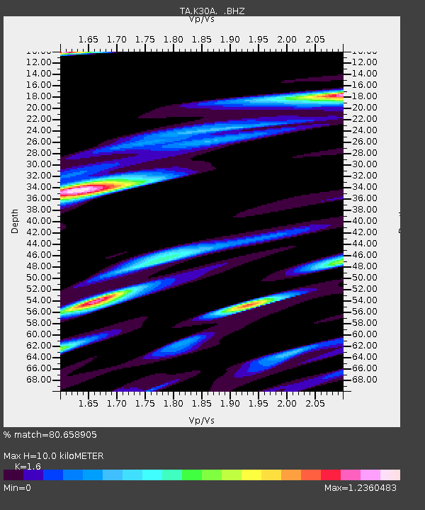
| Estimated Moho Depth: |
10.0 km |
| Estimated Crust Vp/Vs: |
1.60 |
| Assumed Crust Vp: |
6.53 km/s |
| Estimated Crust Vs: |
4.082 km/s |
| Estimated Crust Poisson's Ratio: |
0.18 |
|
| Radial Match: |
80.658905 % |
| Radial Bump: |
400 |
| Transverse Match: |
69.79349 % |
| Transverse Bump: |
400 |
| SOD ConfigId: |
312771 |
| Insert Time: |
2010-06-28 16:46:53.278 +0000 |
| GWidth: |
2.5 |
| Max Bumps: |
400 |
| Tol: |
0.001 |
|
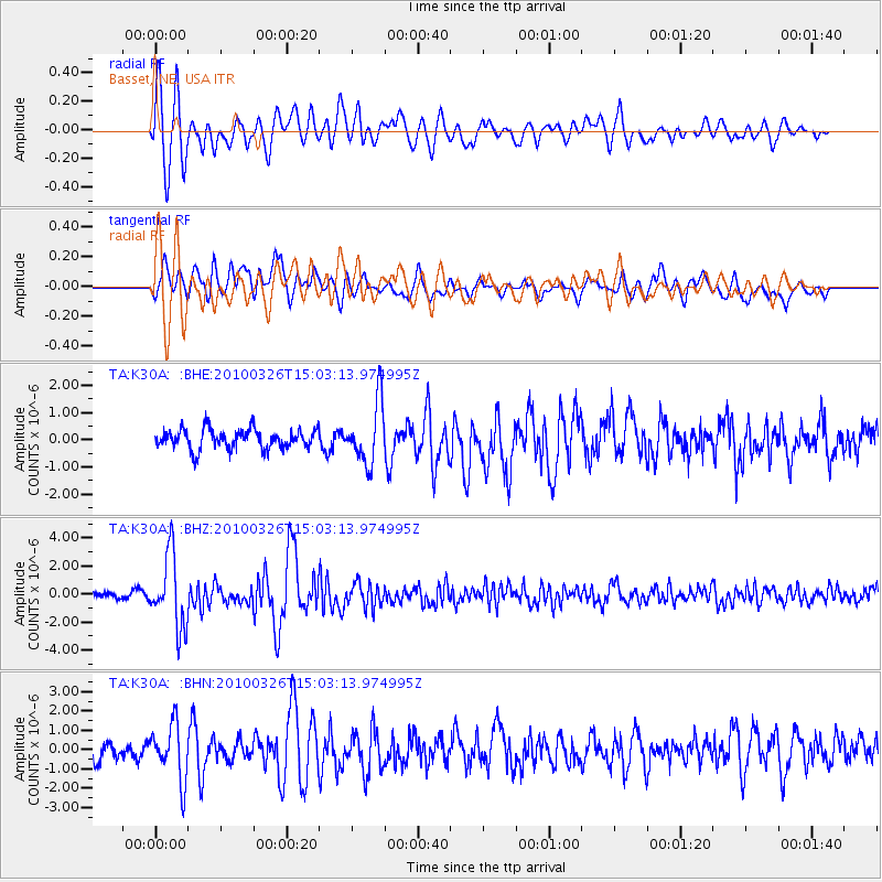
Signal To Noise
| Channel | StoN | STA | LTA |
| TA:K30A: :BHZ:20100326T15:03:13.974995Z | 10.408189 | 2.5700413E-6 | 2.4692494E-7 |
| TA:K30A: :BHN:20100326T15:03:13.974995Z | 3.512813 | 1.4556554E-6 | 4.1438452E-7 |
| TA:K30A: :BHE:20100326T15:03:13.974995Z | 3.066453 | 1.1093781E-6 | 3.6177894E-7 |
| Arrivals |
| Ps | 1.0 SECOND |
| PpPs | 3.8 SECOND |
| PsPs/PpSs | 4.8 SECOND |


