You are here: Home > Network List > US - United States National Seismic Network Stations List
> Station EGMT Eagleton, Montana, USA > Earthquake Result Viewer
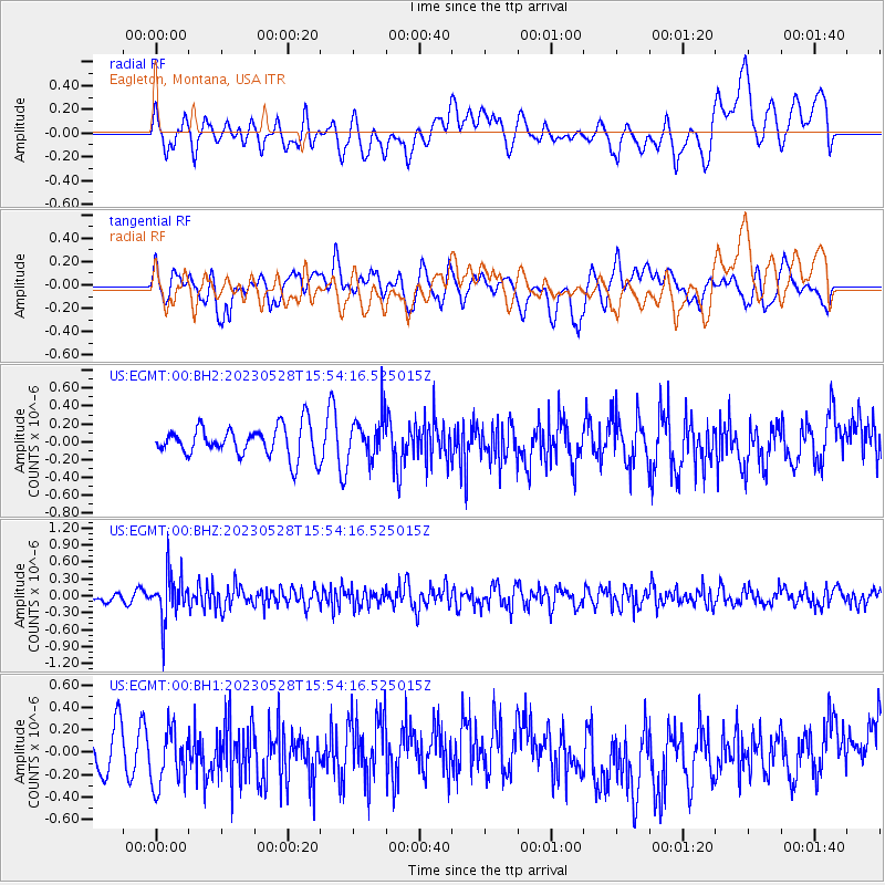
EGMT Eagleton, Montana, USA - Earthquake Result Viewer
*The percent match for this event was below the threshold and hence no stack was calculated.
| Earthquake location: |
Northern Colombia |
| Earthquake latitude/longitude: |
6.7/-73.0 |
| Earthquake time(UTC): |
2023/05/28 (148) 15:45:56 GMT |
| Earthquake Depth: |
158 km |
| Earthquake Magnitude: |
5.3 Mww |
| Earthquake Catalog/Contributor: |
NEIC PDE/us |
|
| Network: |
US United States National Seismic Network |
| Station: |
EGMT Eagleton, Montana, USA |
| Lat/Lon: |
48.02 N/109.75 W |
| Elevation: |
1055 m |
|
| Distance: |
51.6 deg |
| Az: |
329.201 deg |
| Baz: |
130.749 deg |
| Ray Param: |
$rayparam |
*The percent match for this event was below the threshold and hence was not used in the summary stack. |
|
| Radial Match: |
43.62186 % |
| Radial Bump: |
400 |
| Transverse Match: |
49.7519 % |
| Transverse Bump: |
400 |
| SOD ConfigId: |
30536071 |
| Insert Time: |
2023-06-11 16:15:58.484 +0000 |
| GWidth: |
2.5 |
| Max Bumps: |
400 |
| Tol: |
0.001 |
|
Signal To Noise
| Channel | StoN | STA | LTA |
| US:EGMT:00:BHZ:20230528T15:54:16.525015Z | 5.123743 | 4.043151E-7 | 7.8910105E-8 |
| US:EGMT:00:BH1:20230528T15:54:16.525015Z | 1.5226492 | 2.5957516E-7 | 1.7047601E-7 |
| US:EGMT:00:BH2:20230528T15:54:16.525015Z | 1.461593 | 2.4810424E-7 | 1.6974919E-7 |
| Arrivals |
| Ps | |
| PpPs | |
| PsPs/PpSs | |


