You are here: Home > Network List > TA - USArray Transportable Network (new EarthScope stations) Stations List
> Station L02D Cave Junction, OR, USA > Earthquake Result Viewer
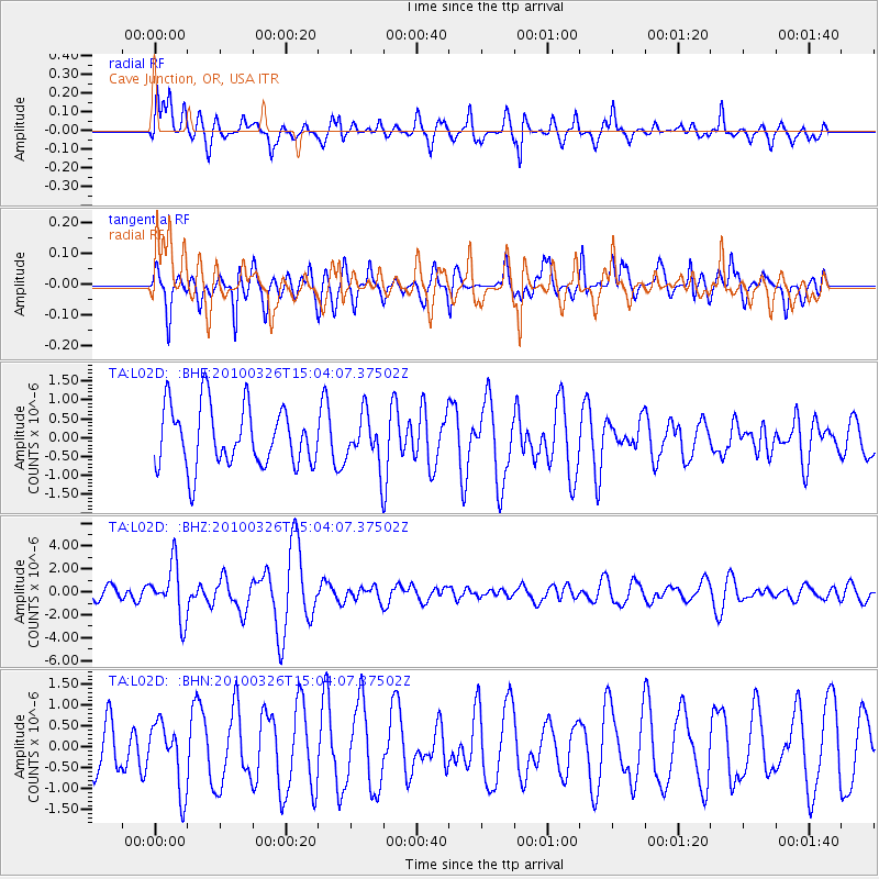
L02D Cave Junction, OR, USA - Earthquake Result Viewer
*The percent match for this event was below the threshold and hence no stack was calculated.
| Earthquake location: |
Near Coast Of Northern Chile |
| Earthquake latitude/longitude: |
-28.0/-70.8 |
| Earthquake time(UTC): |
2010/03/26 (085) 14:52:07 GMT |
| Earthquake Depth: |
42 km |
| Earthquake Magnitude: |
6.2 MB, 5.9 MS, 6.3 MW, 6.1 MW |
| Earthquake Catalog/Contributor: |
WHDF/NEIC |
|
| Network: |
TA USArray Transportable Network (new EarthScope stations) |
| Station: |
L02D Cave Junction, OR, USA |
| Lat/Lon: |
42.16 N/123.60 W |
| Elevation: |
458 m |
|
| Distance: |
85.1 deg |
| Az: |
323.536 deg |
| Baz: |
135.001 deg |
| Ray Param: |
$rayparam |
*The percent match for this event was below the threshold and hence was not used in the summary stack. |
|
| Radial Match: |
70.05201 % |
| Radial Bump: |
400 |
| Transverse Match: |
61.69221 % |
| Transverse Bump: |
389 |
| SOD ConfigId: |
312771 |
| Insert Time: |
2010-06-28 16:49:35.509 +0000 |
| GWidth: |
2.5 |
| Max Bumps: |
400 |
| Tol: |
0.001 |
|
Signal To Noise
| Channel | StoN | STA | LTA |
| TA:L02D: :BHZ:20100326T15:04:07.37502Z | 3.6805046 | 2.3210946E-6 | 6.3064573E-7 |
| TA:L02D: :BHN:20100326T15:04:07.37502Z | 1.1426842 | 7.948819E-7 | 6.956269E-7 |
| TA:L02D: :BHE:20100326T15:04:07.37502Z | 0.8330359 | 6.622514E-7 | 7.9498545E-7 |
| Arrivals |
| Ps | |
| PpPs | |
| PsPs/PpSs | |


