You are here: Home > Network List > TA - USArray Transportable Network (new EarthScope stations) Stations List
> Station 233A Rising Star, TX, USA > Earthquake Result Viewer
233A Rising Star, TX, USA - Earthquake Result Viewer
| Earthquake location: |
Near Coast Of Northern Chile |
| Earthquake latitude/longitude: |
-28.0/-70.8 |
| Earthquake time(UTC): |
2010/03/26 (085) 14:52:07 GMT |
| Earthquake Depth: |
42 km |
| Earthquake Magnitude: |
6.2 MB, 5.9 MS, 6.3 MW, 6.1 MW |
| Earthquake Catalog/Contributor: |
WHDF/NEIC |
|
| Network: |
TA USArray Transportable Network (new EarthScope stations) |
| Station: |
233A Rising Star, TX, USA |
| Lat/Lon: |
32.02 N/98.90 W |
| Elevation: |
539 m |
|
| Distance: |
65.4 deg |
| Az: |
333.902 deg |
| Baz: |
152.735 deg |
| Ray Param: |
0.058246385 |
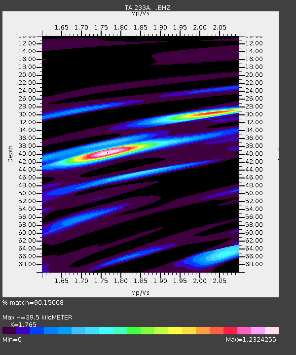
| Estimated Moho Depth: |
39.5 km |
| Estimated Crust Vp/Vs: |
1.76 |
| Assumed Crust Vp: |
6.426 km/s |
| Estimated Crust Vs: |
3.641 km/s |
| Estimated Crust Poisson's Ratio: |
0.26 |
|
| Radial Match: |
90.15008 % |
| Radial Bump: |
400 |
| Transverse Match: |
79.64971 % |
| Transverse Bump: |
400 |
| SOD ConfigId: |
312771 |
| Insert Time: |
2010-06-28 16:50:34.907 +0000 |
| GWidth: |
2.5 |
| Max Bumps: |
400 |
| Tol: |
0.001 |
|
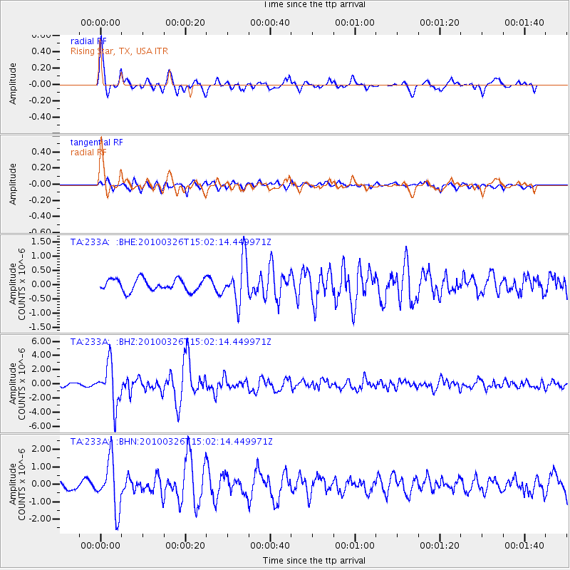
Signal To Noise
| Channel | StoN | STA | LTA |
| TA:233A: :BHZ:20100326T15:02:14.449971Z | 11.841226 | 3.0307795E-6 | 2.5595148E-7 |
| TA:233A: :BHN:20100326T15:02:14.449971Z | 6.478261 | 1.4602523E-6 | 2.2540807E-7 |
| TA:233A: :BHE:20100326T15:02:14.449971Z | 3.6984918 | 7.7085133E-7 | 2.0842317E-7 |
| Arrivals |
| Ps | 4.9 SECOND |
| PpPs | 16 SECOND |
| PsPs/PpSs | 21 SECOND |


