You are here: Home > Network List > TA - USArray Transportable Network (new EarthScope stations) Stations List
> Station 832A Faith Ranch, Carrizo Springs, TX, USA > Earthquake Result Viewer
832A Faith Ranch, Carrizo Springs, TX, USA - Earthquake Result Viewer
| Earthquake location: |
Near Coast Of Northern Chile |
| Earthquake latitude/longitude: |
-28.0/-70.8 |
| Earthquake time(UTC): |
2010/03/26 (085) 14:52:07 GMT |
| Earthquake Depth: |
42 km |
| Earthquake Magnitude: |
6.2 MB, 5.9 MS, 6.3 MW, 6.1 MW |
| Earthquake Catalog/Contributor: |
WHDF/NEIC |
|
| Network: |
TA USArray Transportable Network (new EarthScope stations) |
| Station: |
832A Faith Ranch, Carrizo Springs, TX, USA |
| Lat/Lon: |
28.28 N/99.97 W |
| Elevation: |
238 m |
|
| Distance: |
62.5 deg |
| Az: |
331.033 deg |
| Baz: |
150.936 deg |
| Ray Param: |
0.06009384 |
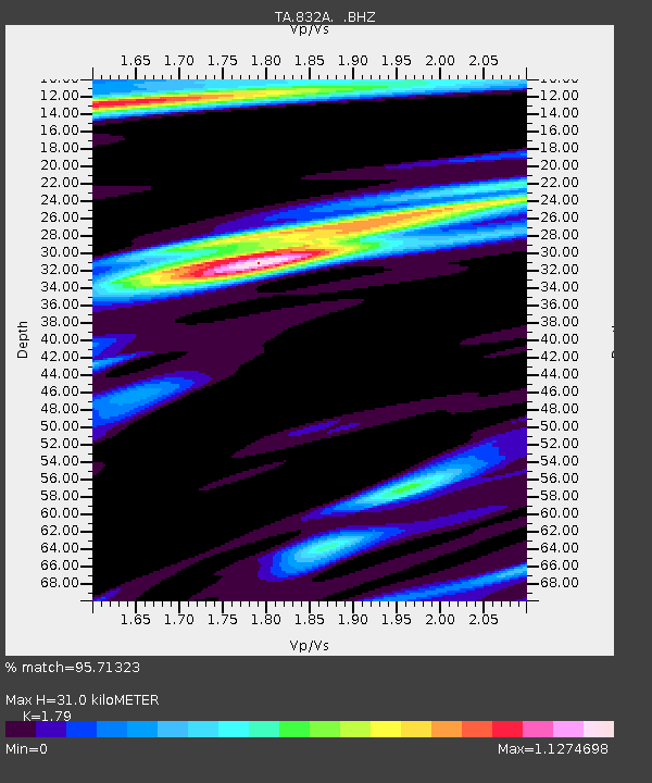
| Estimated Moho Depth: |
31.0 km |
| Estimated Crust Vp/Vs: |
1.79 |
| Assumed Crust Vp: |
6.347 km/s |
| Estimated Crust Vs: |
3.546 km/s |
| Estimated Crust Poisson's Ratio: |
0.27 |
|
| Radial Match: |
95.71323 % |
| Radial Bump: |
354 |
| Transverse Match: |
76.06541 % |
| Transverse Bump: |
400 |
| SOD ConfigId: |
312771 |
| Insert Time: |
2010-06-28 16:51:23.881 +0000 |
| GWidth: |
2.5 |
| Max Bumps: |
400 |
| Tol: |
0.001 |
|
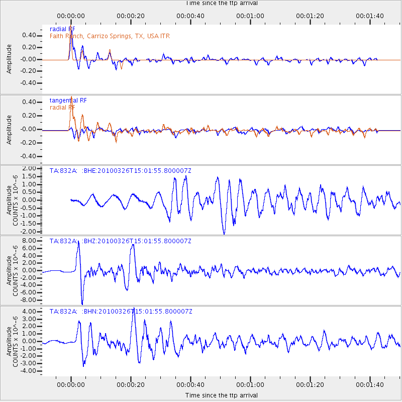
Signal To Noise
| Channel | StoN | STA | LTA |
| TA:832A: :BHZ:20100326T15:01:55.800007Z | 21.212309 | 4.140482E-6 | 1.9519241E-7 |
| TA:832A: :BHN:20100326T15:01:55.800007Z | 7.643935 | 1.6133398E-6 | 2.1106142E-7 |
| TA:832A: :BHE:20100326T15:01:55.800007Z | 3.0572915 | 7.475374E-7 | 2.445097E-7 |
| Arrivals |
| Ps | 4.0 SECOND |
| PpPs | 13 SECOND |
| PsPs/PpSs | 17 SECOND |


