You are here: Home > Network List > AK - Alaska Regional Network Stations List
> Station I21K Tanana, AK, USA > Earthquake Result Viewer
I21K Tanana, AK, USA - Earthquake Result Viewer
| Earthquake location: |
Volcano Islands, Japan Region |
| Earthquake latitude/longitude: |
24.1/143.0 |
| Earthquake time(UTC): |
2023/05/30 (150) 00:52:06 GMT |
| Earthquake Depth: |
10 km |
| Earthquake Magnitude: |
5.8 Mww |
| Earthquake Catalog/Contributor: |
NEIC PDE/us |
|
| Network: |
AK Alaska Regional Network |
| Station: |
I21K Tanana, AK, USA |
| Lat/Lon: |
65.18 N/151.98 W |
| Elevation: |
248 m |
|
| Distance: |
57.9 deg |
| Az: |
26.828 deg |
| Baz: |
257.794 deg |
| Ray Param: |
0.06316628 |
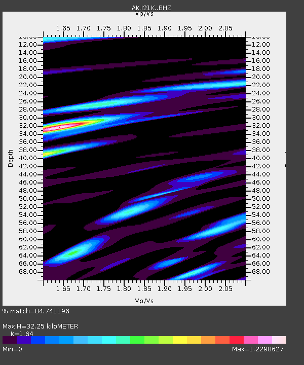
| Estimated Moho Depth: |
32.25 km |
| Estimated Crust Vp/Vs: |
1.64 |
| Assumed Crust Vp: |
6.566 km/s |
| Estimated Crust Vs: |
4.004 km/s |
| Estimated Crust Poisson's Ratio: |
0.20 |
|
| Radial Match: |
84.741196 % |
| Radial Bump: |
400 |
| Transverse Match: |
76.06122 % |
| Transverse Bump: |
400 |
| SOD ConfigId: |
30536071 |
| Insert Time: |
2023-06-13 00:55:49.176 +0000 |
| GWidth: |
2.5 |
| Max Bumps: |
400 |
| Tol: |
0.001 |
|

Signal To Noise
| Channel | StoN | STA | LTA |
| AK:I21K: :BHZ:20230530T01:01:27.520018Z | 4.976672 | 4.3167276E-7 | 8.673924E-8 |
| AK:I21K: :BHN:20230530T01:01:27.520018Z | 1.2912409 | 1.0937114E-7 | 8.470235E-8 |
| AK:I21K: :BHE:20230530T01:01:27.520018Z | 2.2634447 | 2.2478811E-7 | 9.9312395E-8 |
| Arrivals |
| Ps | 3.3 SECOND |
| PpPs | 12 SECOND |
| PsPs/PpSs | 16 SECOND |


