You are here: Home > Network List > TA - USArray Transportable Network (new EarthScope stations) Stations List
> Station 138A Matatall Enterprise, Big Sandy, TX, USA > Earthquake Result Viewer
138A Matatall Enterprise, Big Sandy, TX, USA - Earthquake Result Viewer
| Earthquake location: |
Near Coast Of Northern Chile |
| Earthquake latitude/longitude: |
-28.0/-70.8 |
| Earthquake time(UTC): |
2010/03/26 (085) 14:52:07 GMT |
| Earthquake Depth: |
42 km |
| Earthquake Magnitude: |
6.2 MB, 5.9 MS, 6.3 MW, 6.1 MW |
| Earthquake Catalog/Contributor: |
WHDF/NEIC |
|
| Network: |
TA USArray Transportable Network (new EarthScope stations) |
| Station: |
138A Matatall Enterprise, Big Sandy, TX, USA |
| Lat/Lon: |
32.66 N/95.09 W |
| Elevation: |
143 m |
|
| Distance: |
64.5 deg |
| Az: |
337.42 deg |
| Baz: |
156.254 deg |
| Ray Param: |
0.05877554 |
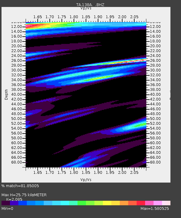
| Estimated Moho Depth: |
25.75 km |
| Estimated Crust Vp/Vs: |
2.09 |
| Assumed Crust Vp: |
6.245 km/s |
| Estimated Crust Vs: |
2.995 km/s |
| Estimated Crust Poisson's Ratio: |
0.35 |
|
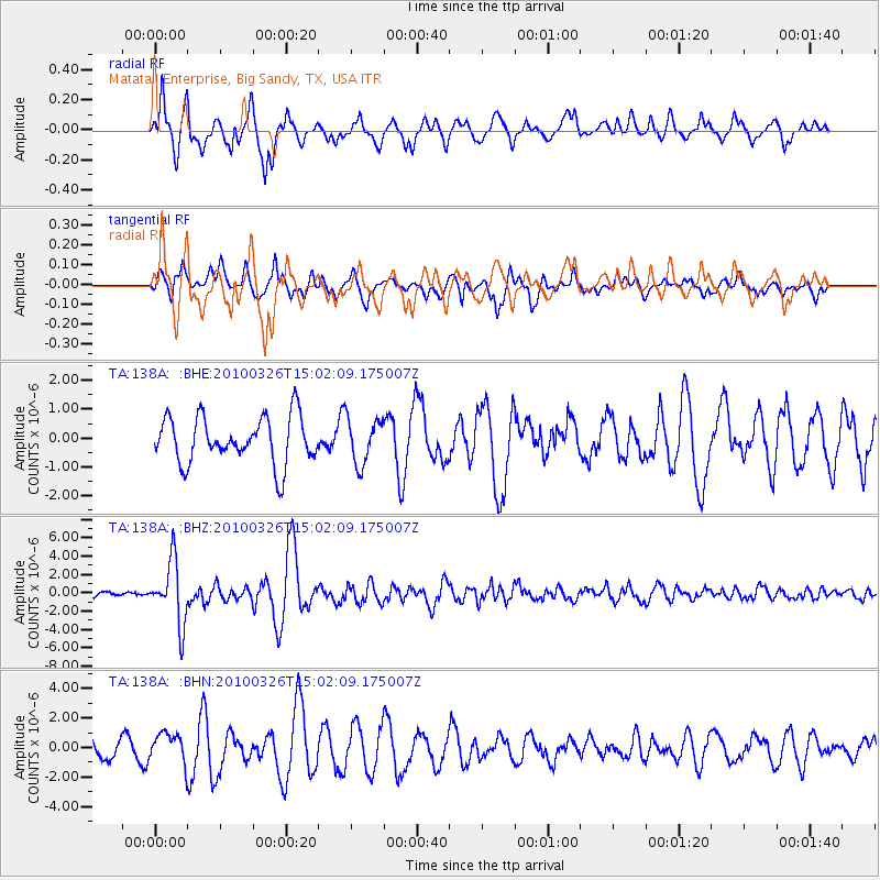
| Radial Match: |
81.85005 % |
| Radial Bump: |
400 |
| Transverse Match: |
60.869843 % |
| Transverse Bump: |
382 |
| SOD ConfigId: |
312771 |
| Insert Time: |
2010-06-28 16:53:51.175 +0000 |
| GWidth: |
2.5 |
| Max Bumps: |
400 |
| Tol: |
0.001 |
|
Signal To Noise
| Channel | StoN | STA | LTA |
| TA:138A: :BHZ:20100326T15:02:09.175007Z | 11.687768 | 3.408916E-6 | 2.916653E-7 |
| TA:138A: :BHN:20100326T15:02:09.175007Z | 1.5434635 | 9.925511E-7 | 6.4306744E-7 |
| TA:138A: :BHE:20100326T15:02:09.175007Z | 0.97343373 | 7.8072526E-7 | 8.020323E-7 |
| Arrivals |
| Ps | 4.6 SECOND |
| PpPs | 12 SECOND |
| PsPs/PpSs | 17 SECOND |


