You are here: Home > Network List > TA - USArray Transportable Network (new EarthScope stations) Stations List
> Station 137A Heron Place, Grans Saline, TX, USA > Earthquake Result Viewer
137A Heron Place, Grans Saline, TX, USA - Earthquake Result Viewer
| Earthquake location: |
Near Coast Of Northern Chile |
| Earthquake latitude/longitude: |
-28.0/-70.8 |
| Earthquake time(UTC): |
2010/03/26 (085) 14:52:07 GMT |
| Earthquake Depth: |
42 km |
| Earthquake Magnitude: |
6.2 MB, 5.9 MS, 6.3 MW, 6.1 MW |
| Earthquake Catalog/Contributor: |
WHDF/NEIC |
|
| Network: |
TA USArray Transportable Network (new EarthScope stations) |
| Station: |
137A Heron Place, Grans Saline, TX, USA |
| Lat/Lon: |
32.60 N/95.76 W |
| Elevation: |
141 m |
|
| Distance: |
64.7 deg |
| Az: |
336.823 deg |
| Baz: |
155.64 deg |
| Ray Param: |
0.058665626 |
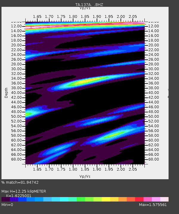
| Estimated Moho Depth: |
12.25 km |
| Estimated Crust Vp/Vs: |
1.62 |
| Assumed Crust Vp: |
6.245 km/s |
| Estimated Crust Vs: |
3.849 km/s |
| Estimated Crust Poisson's Ratio: |
0.19 |
|
| Radial Match: |
81.94742 % |
| Radial Bump: |
400 |
| Transverse Match: |
74.55754 % |
| Transverse Bump: |
400 |
| SOD ConfigId: |
312771 |
| Insert Time: |
2010-06-28 16:54:03.203 +0000 |
| GWidth: |
2.5 |
| Max Bumps: |
400 |
| Tol: |
0.001 |
|

Signal To Noise
| Channel | StoN | STA | LTA |
| TA:137A: :BHZ:20100326T15:02:10.300007Z | 22.99764 | 3.923684E-6 | 1.7061244E-7 |
| TA:137A: :BHN:20100326T15:02:10.300007Z | 2.4850264 | 9.77631E-7 | 3.934087E-7 |
| TA:137A: :BHE:20100326T15:02:10.300007Z | 0.72195834 | 5.6796756E-7 | 7.867041E-7 |
| Arrivals |
| Ps | 1.3 SECOND |
| PpPs | 4.9 SECOND |
| PsPs/PpSs | 6.2 SECOND |


