You are here: Home > Network List > NM - Cooperative New Madrid Seismic Network Stations List
> Station PEBM Pemiscot Bayou,MO > Earthquake Result Viewer
PEBM Pemiscot Bayou,MO - Earthquake Result Viewer
| Earthquake location: |
Northern Chile |
| Earthquake latitude/longitude: |
-19.6/-69.3 |
| Earthquake time(UTC): |
2018/11/01 (305) 22:19:51 GMT |
| Earthquake Depth: |
102 km |
| Earthquake Magnitude: |
6.2 Mww |
| Earthquake Catalog/Contributor: |
NEIC PDE/us |
|
| Network: |
NM Cooperative New Madrid Seismic Network |
| Station: |
PEBM Pemiscot Bayou,MO |
| Lat/Lon: |
36.11 N/89.86 W |
| Elevation: |
76 m |
|
| Distance: |
58.7 deg |
| Az: |
340.556 deg |
| Baz: |
157.195 deg |
| Ray Param: |
0.06236298 |
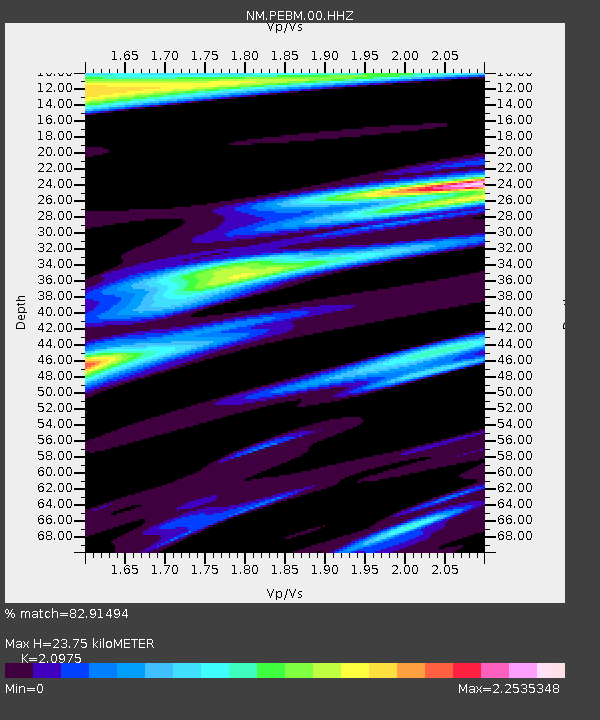
| Estimated Moho Depth: |
23.75 km |
| Estimated Crust Vp/Vs: |
2.10 |
| Assumed Crust Vp: |
6.444 km/s |
| Estimated Crust Vs: |
3.072 km/s |
| Estimated Crust Poisson's Ratio: |
0.35 |
|
| Radial Match: |
82.91494 % |
| Radial Bump: |
400 |
| Transverse Match: |
59.60809 % |
| Transverse Bump: |
400 |
| SOD ConfigId: |
3131071 |
| Insert Time: |
2018-11-15 22:27:33.821 +0000 |
| GWidth: |
2.5 |
| Max Bumps: |
400 |
| Tol: |
0.001 |
|

Signal To Noise
| Channel | StoN | STA | LTA |
| NM:PEBM:00:HHZ:20181101T22:29:07.940024Z | 14.898736 | 4.613315E-6 | 3.0964475E-7 |
| NM:PEBM:00:HHN:20181101T22:29:07.940024Z | 4.0274143 | 2.709968E-6 | 6.7288033E-7 |
| NM:PEBM:00:HHE:20181101T22:29:07.940024Z | 2.4738803 | 2.031357E-6 | 8.211218E-7 |
| Arrivals |
| Ps | 4.2 SECOND |
| PpPs | 11 SECOND |
| PsPs/PpSs | 15 SECOND |


