You are here: Home > Network List > AV - Alaska Volcano Observatory Stations List
> Station SPNN North Nagishlamina, Mount Spurr, Alaska > Earthquake Result Viewer
SPNN North Nagishlamina, Mount Spurr, Alaska - Earthquake Result Viewer
| Earthquake location: |
Volcano Islands, Japan Region |
| Earthquake latitude/longitude: |
24.1/143.0 |
| Earthquake time(UTC): |
2023/05/30 (150) 00:52:06 GMT |
| Earthquake Depth: |
10 km |
| Earthquake Magnitude: |
5.8 Mww |
| Earthquake Catalog/Contributor: |
NEIC PDE/us |
|
| Network: |
AV Alaska Volcano Observatory |
| Station: |
SPNN North Nagishlamina, Mount Spurr, Alaska |
| Lat/Lon: |
61.37 N/152.70 W |
| Elevation: |
1666 m |
|
| Distance: |
56.9 deg |
| Az: |
31.208 deg |
| Baz: |
259.512 deg |
| Ray Param: |
0.06385375 |
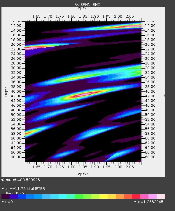
| Estimated Moho Depth: |
11.75 km |
| Estimated Crust Vp/Vs: |
2.10 |
| Assumed Crust Vp: |
6.566 km/s |
| Estimated Crust Vs: |
3.13 km/s |
| Estimated Crust Poisson's Ratio: |
0.35 |
|
| Radial Match: |
88.539925 % |
| Radial Bump: |
400 |
| Transverse Match: |
81.12844 % |
| Transverse Bump: |
400 |
| SOD ConfigId: |
30536071 |
| Insert Time: |
2023-06-13 01:01:39.953 +0000 |
| GWidth: |
2.5 |
| Max Bumps: |
400 |
| Tol: |
0.001 |
|

Signal To Noise
| Channel | StoN | STA | LTA |
| AV:SPNN: :BHZ:20230530T01:01:19.958983Z | 7.55471 | 6.681302E-7 | 8.8438895E-8 |
| AV:SPNN: :BHN:20230530T01:01:19.958983Z | 0.99559057 | 1.03633205E-7 | 1.04092194E-7 |
| AV:SPNN: :BHE:20230530T01:01:19.958983Z | 2.9781373 | 2.7868305E-7 | 9.35763E-8 |
| Arrivals |
| Ps | 2.1 SECOND |
| PpPs | 5.3 SECOND |
| PsPs/PpSs | 7.4 SECOND |


