You are here: Home > Network List > US - United States National Seismic Network Stations List
> Station AMTX Amarillo, Texas, USA > Earthquake Result Viewer
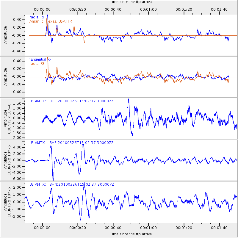
AMTX Amarillo, Texas, USA - Earthquake Result Viewer
*The percent match for this event was below the threshold and hence no stack was calculated.
| Earthquake location: |
Near Coast Of Northern Chile |
| Earthquake latitude/longitude: |
-28.0/-70.8 |
| Earthquake time(UTC): |
2010/03/26 (085) 14:52:07 GMT |
| Earthquake Depth: |
42 km |
| Earthquake Magnitude: |
6.2 MB, 5.9 MS, 6.3 MW, 6.1 MW |
| Earthquake Catalog/Contributor: |
WHDF/NEIC |
|
| Network: |
US United States National Seismic Network |
| Station: |
AMTX Amarillo, Texas, USA |
| Lat/Lon: |
34.53 N/101.41 W |
| Elevation: |
1010 m |
|
| Distance: |
68.6 deg |
| Az: |
333.169 deg |
| Baz: |
151.077 deg |
| Ray Param: |
$rayparam |
*The percent match for this event was below the threshold and hence was not used in the summary stack. |
|
| Radial Match: |
81.4045 % |
| Radial Bump: |
400 |
| Transverse Match: |
77.65359 % |
| Transverse Bump: |
400 |
| SOD ConfigId: |
312771 |
| Insert Time: |
2010-06-28 16:57:17.083 +0000 |
| GWidth: |
2.5 |
| Max Bumps: |
400 |
| Tol: |
0.001 |
|
Signal To Noise
| Channel | StoN | STA | LTA |
| US:AMTX: :BHZ:20100326T15:02:37.300007Z | 9.642875 | 1.5219262E-6 | 1.578291E-7 |
| US:AMTX: :BHN:20100326T15:02:37.300007Z | 1.5577968 | 6.065298E-7 | 3.8935102E-7 |
| US:AMTX: :BHE:20100326T15:02:37.300007Z | 1.0910786 | 3.463502E-7 | 3.1743835E-7 |
| Arrivals |
| Ps | |
| PpPs | |
| PsPs/PpSs | |


