You are here: Home > Network List > IW - Intermountain West Stations List
> Station MOOW Moose Ponds, Wyoming, USA > Earthquake Result Viewer
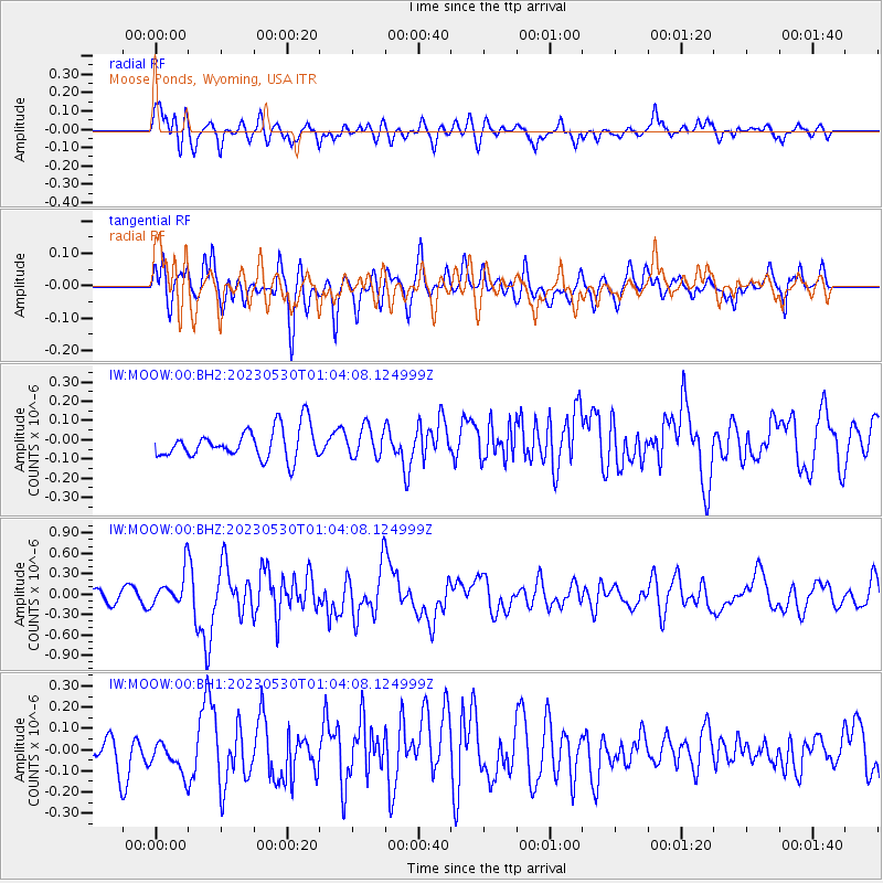
MOOW Moose Ponds, Wyoming, USA - Earthquake Result Viewer
*The percent match for this event was below the threshold and hence no stack was calculated.
| Earthquake location: |
Volcano Islands, Japan Region |
| Earthquake latitude/longitude: |
24.1/143.0 |
| Earthquake time(UTC): |
2023/05/30 (150) 00:52:06 GMT |
| Earthquake Depth: |
10 km |
| Earthquake Magnitude: |
5.8 Mww |
| Earthquake Catalog/Contributor: |
NEIC PDE/us |
|
| Network: |
IW Intermountain West |
| Station: |
MOOW Moose Ponds, Wyoming, USA |
| Lat/Lon: |
43.75 N/110.74 W |
| Elevation: |
2128 m |
|
| Distance: |
84.6 deg |
| Az: |
44.341 deg |
| Baz: |
298.161 deg |
| Ray Param: |
$rayparam |
*The percent match for this event was below the threshold and hence was not used in the summary stack. |
|
| Radial Match: |
67.83 % |
| Radial Bump: |
400 |
| Transverse Match: |
63.33188 % |
| Transverse Bump: |
400 |
| SOD ConfigId: |
30536071 |
| Insert Time: |
2023-06-13 01:11:39.516 +0000 |
| GWidth: |
2.5 |
| Max Bumps: |
400 |
| Tol: |
0.001 |
|
Signal To Noise
| Channel | StoN | STA | LTA |
| IW:MOOW:00:BHZ:20230530T01:04:08.124999Z | 2.9237285 | 2.5104362E-7 | 8.586421E-8 |
| IW:MOOW:00:BH1:20230530T01:04:08.124999Z | 0.90279365 | 8.584782E-8 | 9.50913E-8 |
| IW:MOOW:00:BH2:20230530T01:04:08.124999Z | 0.97052556 | 7.603072E-8 | 7.8339745E-8 |
| Arrivals |
| Ps | |
| PpPs | |
| PsPs/PpSs | |


