You are here: Home > Network List > US - United States National Seismic Network Stations List
> Station EGMT Eagleton, Montana, USA > Earthquake Result Viewer
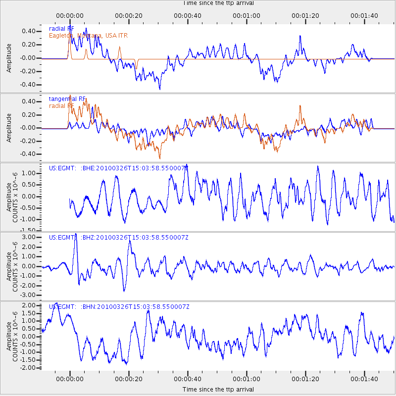
EGMT Eagleton, Montana, USA - Earthquake Result Viewer
*The percent match for this event was below the threshold and hence no stack was calculated.
| Earthquake location: |
Near Coast Of Northern Chile |
| Earthquake latitude/longitude: |
-28.0/-70.8 |
| Earthquake time(UTC): |
2010/03/26 (085) 14:52:07 GMT |
| Earthquake Depth: |
42 km |
| Earthquake Magnitude: |
6.2 MB, 5.9 MS, 6.3 MW, 6.1 MW |
| Earthquake Catalog/Contributor: |
WHDF/NEIC |
|
| Network: |
US United States National Seismic Network |
| Station: |
EGMT Eagleton, Montana, USA |
| Lat/Lon: |
48.02 N/109.75 W |
| Elevation: |
1055 m |
|
| Distance: |
83.3 deg |
| Az: |
334.866 deg |
| Baz: |
145.964 deg |
| Ray Param: |
$rayparam |
*The percent match for this event was below the threshold and hence was not used in the summary stack. |
|
| Radial Match: |
41.46212 % |
| Radial Bump: |
400 |
| Transverse Match: |
54.34901 % |
| Transverse Bump: |
400 |
| SOD ConfigId: |
312771 |
| Insert Time: |
2010-06-28 16:57:30.462 +0000 |
| GWidth: |
2.5 |
| Max Bumps: |
400 |
| Tol: |
0.001 |
|
Signal To Noise
| Channel | StoN | STA | LTA |
| US:EGMT: :BHZ:20100326T15:03:58.550007Z | 6.0661044 | 1.4950294E-6 | 2.4645627E-7 |
| US:EGMT: :BHN:20100326T15:03:58.550007Z | 1.533811 | 1.1081626E-6 | 7.2248963E-7 |
| US:EGMT: :BHE:20100326T15:03:58.550007Z | 1.1075807 | 5.3458314E-7 | 4.8265844E-7 |
| Arrivals |
| Ps | |
| PpPs | |
| PsPs/PpSs | |


