You are here: Home > Network List > TA - USArray Transportable Network (new EarthScope stations) Stations List
> Station Q24A Divide, CO, USA > Earthquake Result Viewer
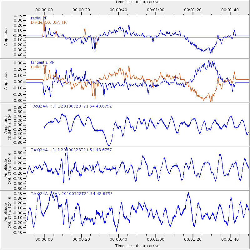
Q24A Divide, CO, USA - Earthquake Result Viewer
*The percent match for this event was below the threshold and hence no stack was calculated.
| Earthquake location: |
Near Coast Of Central Chile |
| Earthquake latitude/longitude: |
-35.4/-72.9 |
| Earthquake time(UTC): |
2010/03/28 (087) 21:43:13 GMT |
| Earthquake Depth: |
22 km |
| Earthquake Magnitude: |
5.5 MB, 5.8 MS, 5.7 MW |
| Earthquake Catalog/Contributor: |
WHDF/NEIC |
|
| Network: |
TA USArray Transportable Network (new EarthScope stations) |
| Station: |
Q24A Divide, CO, USA |
| Lat/Lon: |
38.96 N/105.15 W |
| Elevation: |
2775 m |
|
| Distance: |
79.8 deg |
| Az: |
334.993 deg |
| Baz: |
153.707 deg |
| Ray Param: |
$rayparam |
*The percent match for this event was below the threshold and hence was not used in the summary stack. |
|
| Radial Match: |
37.20629 % |
| Radial Bump: |
400 |
| Transverse Match: |
50.848793 % |
| Transverse Bump: |
400 |
| SOD ConfigId: |
312771 |
| Insert Time: |
2010-06-28 17:05:23.289 +0000 |
| GWidth: |
2.5 |
| Max Bumps: |
400 |
| Tol: |
0.001 |
|
Signal To Noise
| Channel | StoN | STA | LTA |
| TA:Q24A: :BHZ:20100328T21:54:48.675Z | 0.4757136 | 1.3313831E-7 | 2.7987073E-7 |
| TA:Q24A: :BHN:20100328T21:54:48.675Z | 3.4288776 | 3.100823E-7 | 9.04326E-8 |
| TA:Q24A: :BHE:20100328T21:54:48.675Z | 3.5306778 | 6.9021957E-7 | 1.9549209E-7 |
| Arrivals |
| Ps | |
| PpPs | |
| PsPs/PpSs | |


