You are here: Home > Network List > TA - USArray Transportable Network (new EarthScope stations) Stations List
> Station 331A San Angelo, TX, USA > Earthquake Result Viewer
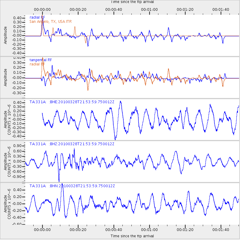
331A San Angelo, TX, USA - Earthquake Result Viewer
*The percent match for this event was below the threshold and hence no stack was calculated.
| Earthquake location: |
Near Coast Of Central Chile |
| Earthquake latitude/longitude: |
-35.4/-72.9 |
| Earthquake time(UTC): |
2010/03/28 (087) 21:43:13 GMT |
| Earthquake Depth: |
22 km |
| Earthquake Magnitude: |
5.5 MB, 5.8 MS, 5.7 MW |
| Earthquake Catalog/Contributor: |
WHDF/NEIC |
|
| Network: |
TA USArray Transportable Network (new EarthScope stations) |
| Station: |
331A San Angelo, TX, USA |
| Lat/Lon: |
31.31 N/100.43 W |
| Elevation: |
615 m |
|
| Distance: |
71.2 deg |
| Az: |
335.302 deg |
| Baz: |
156.498 deg |
| Ray Param: |
$rayparam |
*The percent match for this event was below the threshold and hence was not used in the summary stack. |
|
| Radial Match: |
59.263527 % |
| Radial Bump: |
395 |
| Transverse Match: |
62.53761 % |
| Transverse Bump: |
400 |
| SOD ConfigId: |
312771 |
| Insert Time: |
2010-06-28 17:06:51.523 +0000 |
| GWidth: |
2.5 |
| Max Bumps: |
400 |
| Tol: |
0.001 |
|
Signal To Noise
| Channel | StoN | STA | LTA |
| TA:331A: :BHZ:20100328T21:53:59.750012Z | 1.5271381 | 2.9397341E-7 | 1.9249956E-7 |
| TA:331A: :BHN:20100328T21:53:59.750012Z | 0.45009163 | 5.556983E-8 | 1.2346337E-7 |
| TA:331A: :BHE:20100328T21:53:59.750012Z | 1.4887536 | 1.7031984E-7 | 1.14404315E-7 |
| Arrivals |
| Ps | |
| PpPs | |
| PsPs/PpSs | |


