You are here: Home > Network List > TA - USArray Transportable Network (new EarthScope stations) Stations List
> Station 334A Lometa, TX, USA > Earthquake Result Viewer
334A Lometa, TX, USA - Earthquake Result Viewer
*The percent match for this event was below the threshold and hence no stack was calculated.
| Earthquake location: |
Near Coast Of Central Chile |
| Earthquake latitude/longitude: |
-35.4/-72.9 |
| Earthquake time(UTC): |
2010/03/28 (087) 21:43:13 GMT |
| Earthquake Depth: |
22 km |
| Earthquake Magnitude: |
5.5 MB, 5.8 MS, 5.7 MW |
| Earthquake Catalog/Contributor: |
WHDF/NEIC |
|
| Network: |
TA USArray Transportable Network (new EarthScope stations) |
| Station: |
334A Lometa, TX, USA |
| Lat/Lon: |
31.33 N/98.24 W |
| Elevation: |
389 m |
|
| Distance: |
70.5 deg |
| Az: |
337.141 deg |
| Baz: |
158.233 deg |
| Ray Param: |
$rayparam |
*The percent match for this event was below the threshold and hence was not used in the summary stack. |
|
| Radial Match: |
65.24017 % |
| Radial Bump: |
400 |
| Transverse Match: |
63.54401 % |
| Transverse Bump: |
400 |
| SOD ConfigId: |
312771 |
| Insert Time: |
2010-06-28 17:08:09.406 +0000 |
| GWidth: |
2.5 |
| Max Bumps: |
400 |
| Tol: |
0.001 |
|
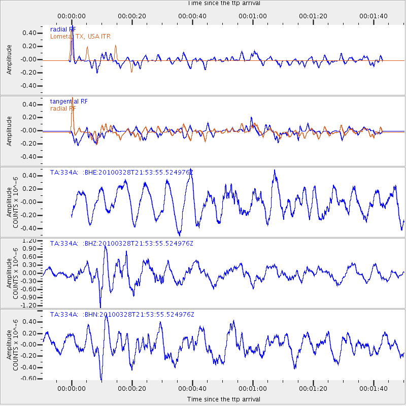
Signal To Noise
| Channel | StoN | STA | LTA |
| TA:334A: :BHZ:20100328T21:53:55.524976Z | 1.0491236 | 1.3995667E-7 | 1.334034E-7 |
| TA:334A: :BHN:20100328T21:53:55.524976Z | 1.1709098 | 1.428203E-7 | 1.2197378E-7 |
| TA:334A: :BHE:20100328T21:53:55.524976Z | 1.1229361 | 2.0721026E-7 | 1.8452542E-7 |
| Arrivals |
| Ps | |
| PpPs | |
| PsPs/PpSs | |


