You are here: Home > Network List > UW - Pacific Northwest Regional Seismic Network Stations List
> Station MRBL Marblemount, WA, USA > Earthquake Result Viewer
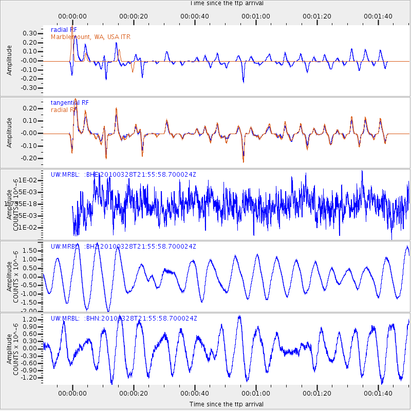
MRBL Marblemount, WA, USA - Earthquake Result Viewer
*The percent match for this event was below the threshold and hence no stack was calculated.
| Earthquake location: |
Near Coast Of Central Chile |
| Earthquake latitude/longitude: |
-35.4/-72.9 |
| Earthquake time(UTC): |
2010/03/28 (087) 21:43:13 GMT |
| Earthquake Depth: |
22 km |
| Earthquake Magnitude: |
5.5 MB, 5.8 MS, 5.7 MW |
| Earthquake Catalog/Contributor: |
WHDF/NEIC |
|
| Network: |
UW Pacific Northwest Regional Seismic Network |
| Station: |
MRBL Marblemount, WA, USA |
| Lat/Lon: |
48.52 N/121.48 W |
| Elevation: |
75 m |
|
| Distance: |
94.1 deg |
| Az: |
330.006 deg |
| Baz: |
142.105 deg |
| Ray Param: |
$rayparam |
*The percent match for this event was below the threshold and hence was not used in the summary stack. |
|
| Radial Match: |
59.858868 % |
| Radial Bump: |
400 |
| Transverse Match: |
59.86785 % |
| Transverse Bump: |
400 |
| SOD ConfigId: |
312771 |
| Insert Time: |
2010-06-28 17:09:42.753 +0000 |
| GWidth: |
2.5 |
| Max Bumps: |
400 |
| Tol: |
0.001 |
|
Signal To Noise
| Channel | StoN | STA | LTA |
| UW:MRBL: :BHZ:20100328T21:55:58.700024Z | 2.754083 | 1.2931695E-6 | 4.6954634E-7 |
| UW:MRBL: :BHN:20100328T21:55:58.700024Z | 0.79347765 | 3.1155548E-7 | 3.9264555E-7 |
| UW:MRBL: :BHE:20100328T21:55:58.700024Z | 0.6884414 | 3.7857633E-9 | 5.499035E-9 |
| Arrivals |
| Ps | |
| PpPs | |
| PsPs/PpSs | |


