You are here: Home > Network List > US - United States National Seismic Network Stations List
> Station ERPA Erie, Pennsylvania, USA > Earthquake Result Viewer
ERPA Erie, Pennsylvania, USA - Earthquake Result Viewer
| Earthquake location: |
Northern Chile |
| Earthquake latitude/longitude: |
-19.6/-69.3 |
| Earthquake time(UTC): |
2018/11/01 (305) 22:19:51 GMT |
| Earthquake Depth: |
102 km |
| Earthquake Magnitude: |
6.2 Mww |
| Earthquake Catalog/Contributor: |
NEIC PDE/us |
|
| Network: |
US United States National Seismic Network |
| Station: |
ERPA Erie, Pennsylvania, USA |
| Lat/Lon: |
42.12 N/79.99 W |
| Elevation: |
306 m |
|
| Distance: |
62.2 deg |
| Az: |
351.017 deg |
| Baz: |
168.588 deg |
| Ray Param: |
0.06010778 |
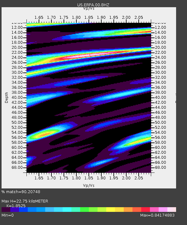
| Estimated Moho Depth: |
22.75 km |
| Estimated Crust Vp/Vs: |
1.85 |
| Assumed Crust Vp: |
6.419 km/s |
| Estimated Crust Vs: |
3.465 km/s |
| Estimated Crust Poisson's Ratio: |
0.29 |
|
| Radial Match: |
90.20748 % |
| Radial Bump: |
400 |
| Transverse Match: |
58.37743 % |
| Transverse Bump: |
400 |
| SOD ConfigId: |
3131071 |
| Insert Time: |
2018-11-15 22:29:57.113 +0000 |
| GWidth: |
2.5 |
| Max Bumps: |
400 |
| Tol: |
0.001 |
|
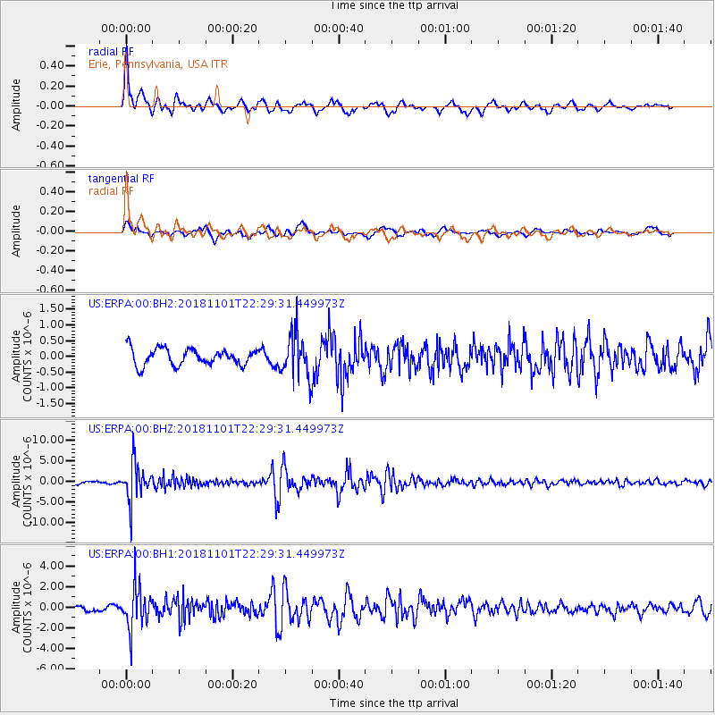
Signal To Noise
| Channel | StoN | STA | LTA |
| US:ERPA:00:BHZ:20181101T22:29:31.449973Z | 9.755498 | 4.52296E-6 | 4.6363186E-7 |
| US:ERPA:00:BH1:20181101T22:29:31.449973Z | 5.7463818 | 2.0188954E-6 | 3.513333E-7 |
| US:ERPA:00:BH2:20181101T22:29:31.449973Z | 2.6338089 | 6.8792986E-7 | 2.61192E-7 |
| Arrivals |
| Ps | 3.2 SECOND |
| PpPs | 9.7 SECOND |
| PsPs/PpSs | 13 SECOND |


